Client Success Story

Discover How SunTec India is Empowering AI Development with Data Annotation Services

THE CLIENT

Enterprises that Need Data Labeling Support for AI Development

The AI market includes several industries, such as healthcare, finance, education, media, and marketing. The rate of AI adoption and deployment across the globe in the coming decade is expected to be explosive. Despite that, data management (including annotation) represents the largest infrastructure challenge for AI development worldwide. SunTec India helps businesses tackle it by providing data annotation services and related data management and processing support.

Explore snapshots of some of our prominent data labeling projects where our team helped the client by making a measurable difference in their ROI and goals.

PROJECT SNAPSHOT 1

Annotating Solar Panel Images for an Energy Company

solar annotation

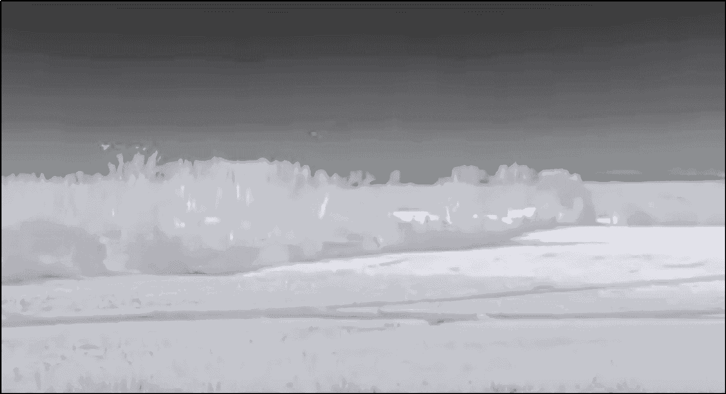
This client is a leading renewable energy company that builds, installs, and manages solar power solutions. They needed precise annotation of thousands of solar panel images to improve their machine learning models for defect detection and efficiency optimization. The images were captured using drones and were divided into RGB (color) and thermal (infrared).

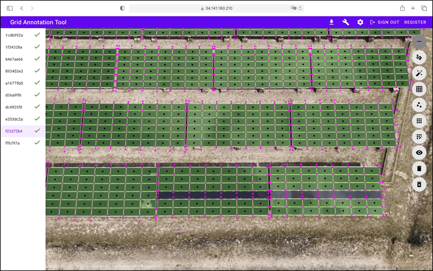
We trained ourselves on the client’s proprietary annotation tool to label the solar panel images, highlighting defects, shading, and installation irregularities, ensuring high-quality and accurate data for the client's AI models.

  • Annotation Tool : Developed and owned by the client
  • Image Annotation Technique : Polyline annotation
  • Team Size : 10 annotators
  • Project Volume : 5000+ images captured by a drone

Our efforts resulted in a 25% increase in the accuracy of the client's defect detection algorithms, significantly enhancing their maintenance efficiency and reducing operational costs by 15%.

PROJECT SNAPSHOT 2

Tracking Drones and Annotating Aerially Shot Videos for a Tech Company

video annotation video annotation

Our client is a technology company specializing in drone-based aerial surveillance and data collection. They needed labeled videos of drones flying over fields to train their object detection algorithm. However, the footage was shot from other drones using standard and infrared cameras across days and nights, which complicated annotation. Thermal signatures, low-light conditions, and videos where the drone being annotated was too far from the camera presented challenges in labeling.

Additionally, the drones moved unpredictably in various directions—up, down, forward, and backward. This randomness made it difficult for automated tracking algorithms to maintain a consistent lock on the drones' positions. As a result, the video frames needed manual adjustments before they could be annotated.

To address the challenges posed by infrared footage and low-light conditions, we adjusted the opacity of infrared frames to enhance visibility. We made manual adjustments for each frame to compensate for the unpredictable drone movements. This involved manually drawing bounding boxes around the drones and assigning unique identifiers to ensure accurate tracking and annotation.

  • Image Annotation Tool : Locally hosted CVAT
  • Image Annotation Technique : Bounding box annotation
  • Team Size : 20 annotators
  • Project Volume : 100,000 frames (55 hours of video)

The SunTec team introduced a 30% improvement in the client's object detection algorithms, significantly enhancing their drone surveillance accuracy. The improved training data also resulted in a 20% increase in operational efficiency.

PROJECT SNAPSHOT 3

Annotating Vehicles in Aerial Images for a Government Agency

Before

aerial image annotation

After

aerial image annotation

The client is a government agency responsible for urban planning and development. They utilize aerial imagery to monitor and manage city traffic and infrastructure. Our team had to annotate those aerial images, i.e., to identify and categorize approximately eight object classes, including cars, SUVs, vans, pedestrians, motorbikes, cyclists, trucks, and buses.

The images varied in resolution and clarity, presenting challenges in accurately identifying and labeling vehicles, especially in densely populated urban areas and under varying lighting conditions. We used 100% zoom to identify the objects and implemented a multi-pass annotation process, which involved multiple rounds of quality checks and adjustments to maintain precision.

  • Image Annotation Tool : Label|mg
  • Image Annotation Technique : Bounding box annotation
  • Team Size : 5 annotators
  • Project Volume : 2000+ images

Our detailed annotation process led to a 35% increase in the accuracy of the agency's traffic analysis models. The enhanced data accuracy also resulted in a 20% improvement in the agency's ability to monitor traffic flow.

PROJECT SNAPSHOT 4

Vehicle Damage Detection and Labeling for an Insurance Company

Before

vehicle damage

After

vehicle damage

Before

vehicle image annotation

After

vehicle image annotation

We collaborated with a leading auto insurance provider in the UK to detect and label vehicle damage in the images submitted for claims (e.g., dent, rust, scratch).

It was challenging to distinguish between dents and reflections caused by shadows. Other issues included identifying dents in darker images and detecting scratches and chips that were not easily visible. Additionally, maintaining consistent output due to variations in image quality posed significant difficulties. We maintained constant feedback loops with the client to overcome these challenges and ensured timely query resolution.

  • Image Annotation Tool : Locally hosted CVAT
  • Image Annotation Technique : Polygon annotation
  • Team Size : 10 annotators
  • Project Volume : 3000 images

Our efforts resulted in a 40% improvement in the accuracy of the client's damage detection algorithms and a 30% reduction in claims assessment time.

PROJECT SNAPSHOT 5

Image Annotation to Identify Litter on Streets for a Municipal Agency

litter annotation

The client is a municipal government department responsible for city maintenance and public services. They needed our assistance to train a street maintenance tracking system. We had to annotate public bins, potholes, manhole covers, and litter in street images.

The challenges in this project included variations in image quality due to different lighting and weather conditions, interference caused by pedestrians or vehicles, and the diverse appearances of objects in various urban environments. We employed bounding box and segmentation techniques to ensure accurate image labeling. Regular feedback sessions with the client helped refine our annotation process and resolve any queries promptly.

  • Image Annotation Tool : Locally hosted CVAT
  • Image Annotation Technique : Bounding box annotation
  • Team Size : 10 annotators
  • Project Volume : 3000 images

Our team’s efforts improved the object detection accuracy of the client’s maintenance tracking system by 45%.

PROJECT SNAPSHOT 6

Annotating Water Bodies in Historical Map Images

water bodies annotation
Water Bodies Annotation

This client- an academic institution -was involved in studying and preserving natural water bodies through historical data analysis. They were training an AI/ML solution for geographic data mapping. To facilitate automated map analysis, they required accurate annotation of water features in historical map images.

However, the maps varied in quality, and issues like faded details and diverse cartographic styles complicated the annotation process. We employed digital restoration to improve image clarity and used a polygon tool to precisely delineate water bodies in the maps.

  • Image Annotation Tool : Locally hosted CVAT
  • Image Annotation Technique : Polygon tool (masking)
  • Team Size : 3 annotators
  • Project Volume : 1200 images

The client noted a 40% improvement in the object detection accuracy of their algorithm, as well as better performance in recognizing and categorizing water bodies.

PROJECT SNAPSHOT 7

Segmenting and Annotating Images of Human Palms for an Astrology App

Hand segmentation

  • Before

    hand
  • After

    hand

Palm lines

  • Before

    palm
  • After

    palm

Hand Mount

  • Before

    palm
  • After

    palm

Finger Point

  • Before

    palm
  • After

    palm

Bottom of Fingers and Hand

  • Before

    Finger Before
  • After

    Finger After

The client is a technology company developing an astrology application for palm reading. They were training an AI algorithm to identify palm lines on the hand images uploaded by users, compare them to existing guidelines, and produce a reading. This endeavor required labeled palm images so the model could be trained to identify palm lines.

We had to classify and label diverse areas, including finger points (5 regions), bottom of fingers (5 regions), and hand mounts (9 different regions per palm). However, the images also had unrecognized areas, like the gaps between fingers, which needed to be categorized. Additionally, unclear images affected palm line recognition. Identifying hand mounts became difficult if the images were captured with varying hand postures.

We made manual alterations to accurately identify and categorize the gaps between fingers that the automated tools could not recognize. We used Google images as references of palm lines for precise labeling. Darker or unclear images were processed by adjusting their opacity. We also passed the labeled images through an in-house QC process to ensure all required points across each palm image were correctly annotated.

  • Image Annotation Tool : LabelBox
  • Image Annotation Technique : Polygon and polyline tools
  • Team Size : 10 annotators
  • Project Volume : 10,000 images

Our team enabled a 25% increase in the application's accuracy in palm line identification.

PROJECT SNAPSHOT 8

Text Annotation for a National Restaurant Chain

This client operates across multiple states. They frequently update the menus (containing beverages and food items) of all outlets and need accurate categorization of each item as alcoholic or non-alcoholic for customer clarity and legal compliance. They hired our text annotation team to review a comprehensive list of menu items and label them accordingly.

  • Text Annotation Tool : MS Excel
  • Text Annotation Technique : Text Classification
  • Team Size : 5 annotators
  • Project Volume : 50,000 records

We appointed a subject matter expert in the field to lead the project, who guided the rest of the team in research and verification methods to identify whether each item in the list contained any alcohol or not. We utilized online resources, including official menus from the restaurant's website and ingredient lists from reputable sources. A double-check system was also implemented where each item labeled as unclear was reviewed by another annotator to ensure accuracy. We finally delivered a comprehensive, verified dataset to the client, enabling them to confidently update their menus.

PROJECT SNAPSHOT 9

Video Annotation to Train a Waste Classification Model

Raw image

Raw image

Annotated image

Annotated image

This client is a leading educational institution renowned for its research contributions in AI and automation. They needed accurate video annotation services to train an AI-driven waste classification system for improving recycling processes. The project involved analyzing footage from CCTV cameras of waste items on conveyor belts.

We customized CVAT to enforce the client's project-specific labeling instructions, automated frame preprocessing, and developed a custom data export pipeline to append client-specific metadata fields to the final training dataset. This enabled us to categorize each item correctly from a fixed list of 16 waste types.

  • Annotation Tool : CVAT
  • Video Annotation Technique : Bounding box labeling with human judgment for edge cases

Our efforts resulted in a 98-99% labeling accuracy, improving model precision by 21% and accelerating the annotation process by 42%, helping the client enhance their AI-driven waste classification system.

Read More
PROJECT SNAPSHOT 10

High-Volume Drone Image Annotation for a Livestock Detection Model

Raw image

Raw image

Annotated image

Annotated image

This client is a leading AgriTech company that uses drones and AI to deliver precise livestock-counting solutions. They required accurate annotation of aerial images captured over large feedyards and pastures to train their livestock detection AI model.

We faced obstacles such as inconsistent lighting, overlapping cattle, and background clutter, which made it challenging to identify object boundaries. To overcome this, we created clear labeling guidelines, used oval-shaped annotations in QuPath for better object representation, and implemented a multi-level quality assurance process that ensured precision.

  • Annotation Tool : QuPath
  • Image Annotation Technique : Oval annotations for precise cattle identification
  • Team Size : 6 annotators
  • Project Volume : 10,000+ aerial images annotated per month

Our efforts achieved 95%+ annotation accuracy, improving the operational efficiency of the client’s livestock detection model.

Read More
PROJECT SNAPSHOT 11

Boosting Corrosion Detection Accuracy with Image Labeling

Raw image

Raw image

Annotated image

Annotated image

This client is an infrastructure digitization company that uses AI to help its end users manage and maintain physical assets. They required precise image segmentation to identify and label corrosion on telecommunication towers.

We addressed the challenge of subjectivity in labeling corrosion, as rust appeared differently across materials and lighting conditions. To ensure consistency across multiple annotators, we created a detailed reference guide that standardized how corrosion should be identified.

  • Annotation Tool : Label Studio
  • Image Annotation Technique : Pixel-level segmentation with smart brush and polygon tools

The project achieved 99% inter-annotator consistency, a 25% improvement in model precision, and 95%+ labeling accuracy, all verified through a multi-stage quality assurance process.

Read More
PROJECT SNAPSHOT 12

AI for Environmental Monitoring: Satellite Image Segmentation for Accurate Water-Ice Detection

Raw image

Raw image

Annotated image

Annotated image

This client is a leading European technology company specializing in environmental monitoring and satellite data analysis. They required precise semantic segmentation on RGB satellite images to train an AI model to distinguish between water, solid ice, and slushy ice across seasonal variations.

We faced challenges distinguishing solid ice from slushy ice and maintaining consistency across the images with seasonal variations. To solve this, we worked with subject matter experts to create clear labeling guidelines, trained annotators extensively, and used CVAT, which is exceptionally effective for labeling tasks that require pixel-level precision.

  • Annotation Tool : CVAT
  • Image Annotation Technique : Semantic segmentation on RGB satellite imagery
  • Team Size : 20 image labeling professionals
  • Project Volume : 8,500 satellite images

We achieved 98% annotation accuracy and a 99% client acceptance rate, exceeding the minimum accuracy threshold and delivering all datasets two weeks ahead of schedule.

Read More
PROJECT SNAPSHOT 13

Precise Food Item Labeling to Train AI Agents for Efficient Restaurant Operation Management

Raw image

Raw image

Annotated image

Annotated image

This client is an AI company specializing in restaurant and food delivery technology. They provide operational solutions (AI agents) to restaurant chains, enabling automated order verification, menu digitization, dispute resolution, and more. To ensure reliable real-world performance for these AI agents, they needed highly accurate image annotations.

We used polygon segmentation to label irregularly shaped food items across a large dataset, ensuring the AI could correctly identify and verify menu items.

  • Annotation Tool : CVAT
  • Image Annotation Technique : Polygon segmentation with human review
  • Team Size : 10 annotators
  • Project Volume : 20,000+ images annotated

Our efforts achieved 98% annotation accuracy. Additionally, by developing a detailed labeling taxonomy that covered diverse food categories, packaging types, regional variations, and restaurant chain-based variations in food items, we enabled multi-chain AI agent deployment without the need for client-specific retraining.

Read More
PROJECT SNAPSHOT 14

Precise Drone Image Annotation for Automated Bird Nest Detection on Power Grids

Raw image

Raw image

Annotated image

Annotated image

This client is a German technology company specializing in digital data collection and AI-powered object detection for asset-intensive industries. They needed accurate drone image annotation for an automated bird nest detection system to monitor power grid infrastructure and ensure safety.

We faced several challenges, such as varying environmental conditions and the need to classify bird nests in crowded or partially obscured images. To address this, we implemented clear guidelines and used precise bounding box annotations, supported by a multi-tier quality assurance process to ensure consistent and accurate labeling.

  • Annotation Tool : Client’s proprietary annotation platform
  • Image Annotation Technique : Bounding box annotation
  • Project Volume : Over 15,000 aerial images

Our efforts resulted in 95%+ annotation accuracy and we also maintained an error rate below 5%.

Read More
PROJECT SNAPSHOT 15

Aerial Image Annotation to Train a River Monitoring AI Model

Raw image

Raw image

Annotated image

Annotated image

This client is a German technology company specializing in AI-powered asset management solutions. They needed high-accuracy image annotation to develop an AI model for detecting river obstructions, ensuring proactive environmental monitoring and effective water resource management.

We faced challenges in distinguishing genuine obstructions from non-obstructive debris and handling varying environmental conditions. To address this, we established clear guidelines and used bounding-box annotations to accurately mark obstructions, enabling the AI system to detect hazards efficiently.

  • Annotation Tool : Client’s proprietary annotation platform
  • Image Annotation Technique : Bounding box annotation
  • Team Size : 6 data annotators
  • Project Volume : 75,000 high-resolution aerial images

Our efforts resulted in 98% labeling accuracy, consistently meeting the client’s quality expectations with a revision/rework rate of less than 1%. We delivered 1,500-2,000 labeled images per week, ensuring timely, scalable data annotation.

Read More

Data Annotation Tools

Our Team is Familiar with Prominent Data Annotation Tools

  • CVAT Logo
    CVAT
  • label image
    Label|mg
  • label Box
    Labelbox
  • v7 logo
    V7
  • Image Annotation
    Image
    Annotation Lab
  • labelstudio Logo
    LabelStudio
  • QuPath Logo
    QuPath

Data Annotation Services

Our Data Annotation Capabilities Include

CONTACT US

Get the Support your Company Needs for Faster AI Development and Accurate Outcomes

SunTec empowers technology and AI companies through reliable data annotation services. Our expertise spans various domains, and we provide high-quality labeled data that fuels the development and deployment of advanced AI models. If you want to know more about our services or speak to a consultant about your AI problems, reach out to us.