A Dedicated Image Annotation Team, Comprehensive Training, and Layered Quality Controls
Meeting the dual demands of high volume and exceptional accuracy required more than standard annotation practices. Our solution combined dedicated resources, specialized training, systematic quality controls, and adaptive workflows to deliver the accuracy, consistency, and reliability the client's AI model required.
Assigning a Dedicated Team of Image Annotation Specialists
We aligned a dedicated team of six full-time data annotators and one full-time Quality Assurance Lead, all with proven expertise in high-volume image annotation. This team worked exclusively on the client's project, gaining a deep familiarity with the annotation guidelines, consistently interpreting edge cases, and maintaining sustained productivity. The dedicated QA Lead provided real-time oversight, immediate feedback, and served as the primary liaison with the client's technical team.
Structured Onboarding to the Client’s Data Annotation Platform
Our team received training on the client's proprietary annotation platform for image labeling to ensure proficiency before production began. This onboarding included hands-on practice with the platform's unique interface, keyboard shortcuts, and workflow requirements, as well as a detailed review of the client's annotation taxonomy and guidelines. By investing in thorough platform familiarization upfront, we minimized errors and maintained productivity targets from the project's early stages.
Continuous Calibration to Address Visual Ambiguity in Aerial Image Annotation
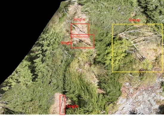
To tackle the challenge of distinguishing genuine obstructions from non-obstructive debris, we created a reference document. Our team identified key visual indicators (such as water flow patterns, object positioning relative to the main channel, and contextual clues) that differentiate flow-blocking obstacles from harmless debris and documented them, allowing each team member to annotate images consistently and accurately.
The QA Lead also held bi-weekly calibration meetings with the client to review challenging edge cases and establish methods for handling them in this drone-based image annotation project.
Batch Processing Workflow for Efficiency and Consistency
Images were distributed in manageable daily batches to each annotator. This approach enabled focused annotation sessions, allowing the QA Lead to review completed batches systematically before delivery. The batching structure also facilitated better tracking of progress, identification of recurring challenges, and timely adjustments to our strategy for this high‑volume image annotation project.
Multi-Tiered Quality Assurance to Meet Client Standards
Since the client expected 96% accuracy from our bounding box annotation services, we implemented additional internal quality measures to exceed expectations:
- Random sampling checks: The QA Lead reviewed 10% of each annotator's daily output to catch errors early.
- Cross-annotation verification: Periodic assignment of the same images to multiple annotators to measure inter-annotator agreement.
- Weekly consensus sessions: Team meetings to discuss edge cases, align on challenging scenarios, and refine classification criteria.
- Edge case library: Documentation of ambiguous scenarios with agreed-upon resolutions, serving as a live reference guide.
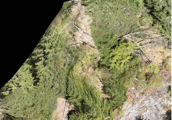
Raw image
Annotated image