AI Training Data Services for Agriculture

Build Reliable Agricultural AI Models With High-Quality, Domain-Specific Training Data

We support the entire training data lifecycle for AI in Agriculture, so your team can focus on model development with faster production cycles.

Get Your AI Training Data Proposal Today

Success Stories

...it's all about results

Livestock Detection

SMART FARMING SOLUTIONS

Processing 10,000+ High-Res Drone Images Monthly with 95% Accuracy for Livestock Detection Model

Read More

AI TRAINING DATA FOR AGRICULTURE

The Data Infrastructure behind Reliable Agricultural AI Applications

Agricultural AI operates in conditions no other industry faces — shifting seasons, unpredictable biology, multi-spectral sensor noise, and terrain that changes county to county, crop to crop, and week to week. That level of variability places unusual demands on model performance. Our AI training data services help agricultural AI teams prepare for that complexity with precise, consistent training datasets.

Whether you are training computer vision applications, developing agronomic language workflows, or building broader agricultural AI systems, we deliver datasets aligned to your model objectives and deployment requirements, while maintaining consistency across data formats and labeling logic.

Proven Domain Expertise

Hands-on experience with agriculture AI training data preparation, including geospatial data annotation, drone imagery processing, and environmental data labeling.

Scale without Sacrificing Quality

Established operational workflows, in-house subject matter experts, and a large workforce with the flexibility to scale teams up or down based on your project's seasonal demands.

Security & Compliance

Your agricultural IP and proprietary datasets are protected at every stage with NDAs, strict internal access governance, data encryption, ISO, HIPAA, and GDPR compliance.

Flexible Engagement Models

Whether you need a short-term pilot (free sample available), a dedicated annotation team for an ongoing program, or burst capacity for a seasonal project, we configure the engagement to your requirements.

AI TRAINING DATA FOR AGRICULTURE: SERVICES

Full-Spectrum Training Data Services for Agricultural AI

From sourcing raw agricultural data and transforming it into ML-ready formats, through precision annotation, to LLM fine-tuning and human-in-the-loop model validation — we provide the data infrastructure your agricultural AI needs to perform accurately across real-world complexity. Our services are customized to your model's architecture, deployment context, and field-level realities. You get one pipeline for all AI data needs. No handoffs between vendors. No inconsistencies between stages.

AI Data Collection for Agriculture

  • Gather high-quality image, video, text, and sensor data from public agricultural databases (USDA NASS, Copernicus, Radiant MLHub) and web-based agronomic sources.
  • Aggregate and integrate client-provided datasets (drone captures, sensor feeds, field records, crop logs) into the training pipeline alongside externally sourced data.
View MoreAI Data Collection Services

Data Preprocessing for Agriculture

  • Clean, normalize, and transform raw agricultural data into machine learning-ready formats.
  • Includes deduplication, format conversion (JSON, CSV, XML, COCO, YOLO, Pascal VOC), PII masking where applicable, and enrichment with external metadata like geospatial coordinates, crop taxonomy, phenological stage markers, and weather context.
View MoreData Preprocessing Services

Agriculture Data Annotation

  • Annotate agricultural data across images, video, LiDAR, sensor streams, and text — with annotation teams trained on project-specific guidelines and relevant edge-case handling.
  • Teams that can work across prominent data labeling tools, such as CVAT, Labelbox, and Label Studio, as well as proprietary annotation platforms.
View MoreData Annotation Services

LLM Fine-Tuning for Agricultural AI

  • Supervised fine-tuning data (prompt-response pairs grounded in agricultural domain knowledge).
  • RLHF annotation to align model outputs with domain-specific expectations.
  • Adversarial red team testing to catch hallucinated recommendations that could lead to crop damage or financial loss.
View MoreLLM Fine-Tuning Services

AI Model Validation for Agriculture

  • Human-in-the-loop validation of your agricultural AI model's outputs
  • Subject matter expert review to catch edge cases (misidentified growth stages, false positive disease detections)
  • Bias audits to ensure your model performs across varying real-world conditions. Consensus-based accuracy checks with multi-annotator agreement protocols.
View MoreAI Model Validation Services

TRAINING DATA FOR AI IN AGRICULTURE: USE CASES

Agricultural AI Training Data Services, Custom-Engineered for Your Model

SunTec India brings deep, hands-on experience in managing the complexities of training data for the agriculture industry. From multispectral satellite imagery to aerial field scans, the data our teams work with every day powers smart agriculture solutions. We maintain this capability through constant training, especially for project-specific agricultural nuances (such as crop taxonomy, disease identification protocols, growth stage classification), as well as by integrating subject matter expert review directly into the QA workflow. This is how we consistently deliver datasets that perform in production for diverse use cases across the Agriculture AI domain.

Crop Health Monitoring

Crop Health Monitoring & Analysis

Annotation Technique: Semantic Segmentation

We classify every pixel in drone and satellite imagery — healthy crop, stressed crop, diseased area, bare soil, and background. To track crop health progression over time, we label sequential captures to track progression through growth stages across seasons.

Output Formats:

PNG masks with class IDs, COCO segmentation polygons, GeoTIFF

Livestock Monitoring

Livestock Monitoring & Precision Dairy

Annotation Technique: Image Categorization + Bounding Boxes + Keypoints

We draw bounding boxes around individual animals and label them with species and breed. We classify posture and activity states for behavior analysis. We also optimize livestock management through high-fidelity skeletal keypoint annotation, enabling models to track gait, posture, and body-condition scoring with clinical precision.

Output Formats:

COCO JSON, YOLO TXT, Pascal VOC XML, custom tracking JSON

Pest & Disease

Pest & Disease Detection

Annotation Technique: Bounding Box + Polygon Annotation

We place tight bounding boxes around affected leaf, stem, and fruit regions and label them by pest species or disease type. For more precise identification of affected areas and classification of severity as mild, moderate, or severe, we use polygon annotation.

Output Formats:

COCO JSON, YOLO TXT, Pascal VOC XML

Field Mapping & Land Intelligence

Annotation Technique: Polygon Annotation

We trace precise polygon boundaries around individual fields, access roads, water bodies, tree lines, and irrigation infrastructure — each with land-use classification labels — at sub-meter precision for cadastral mapping using high-resolution aerial imagery.

Output Formats:

GeoJSON, Shapefile, COCO segmentation polygons

Precision Agriculture & Farm Automation

Annotation Technique: 3D Point Cloud Annotation (LiDAR)

We label point clusters in 3D space to segment ground surface, crop canopy, farm structures, obstacles, and equipment. This multi-sensor data fusion is the backbone of reliable precision farming solutions, allowing autonomous tractors and harvesters to maintain centimeter-level accuracy in complex, dynamic environments.

Output Formats:

PCD files with labels, LAS/LAZ classified point clouds, custom 3D schemas

Climate & Yield Forecasting

Annotation Technique: Time-Series Data Labeling

We label time-series data from weather stations, soil sensors, and satellite captures with event markers — planting date, germination, flowering, drought onset, frost events. We correlate yield data with environmental variables to predict outcomes and support better resource allocation.

Output Formats:

Labeled CSV/JSON with temporal annotations, custom time-series schemas

Smart Irrigation & Water Management

Annotation Technique: Pixel-Level Segmentation

We use thermal and multispectral imagery to classify irrigation zones and reduce water waste. We also annotate irrigation infrastructure — pipe networks, sprinkler zones, and leakage points.

Output Formats:

PNG masks, GeoTIFF with class labels, COCO segmentation polygons

Weed Detection & Smart Spraying

Annotation Technique: Semantic Segmentation

We differentiate crops, weeds, soil, and crop residue at the pixel level — each weed species is labeled with a distinct class. This custom agritech data annotation workflow enables your models to differentiate between crops and invasive species at the seedling stage, drastically reducing herbicide waste and environmental footprint.

Output Formats:

PNG masks with species class IDs, COCO segmentation, YOLO-compatible formats

Agricultural Research & Phenotyping

Annotation Technique: Image Tagging + Multi-Label Classification

We tag plant images with multi-label classifications — growth stage, leaf count, canopy coverage, color indices, and morphological traits. We apply consistent trait vocabularies aligned to your research standards, enabling high-throughput phenotyping.

Output Formats:

Multi-label CSV, COCO JSON with extended attributes, custom phenotyping schemas

Supply Chain & Post-Harvest AI

Annotation Technique: Image Classification

We classify produce images by grade (A, B, C), ripeness level, size category, and defect type (bruising, rot, insect damage, discoloration). The same annotation logic can also be applied to video frames used in automated conveyor-line sorting environments.

Output Formats:

Image classification labels (CSV/JSON), COCO with quality attributes

Satellite & Remote Sensing in Agriculture

Annotation Technique: Land Cover Classification (Semantic Segmentation)

We perform multi-class segmentation on satellite tiles — cropland, forest, urban, water, barren land, and wetland. Leveraging expertise in remote sensing in agriculture, we provide paired temporal annotations that allow models to "see" change over time, while spectral classification helps identify NDVI-based vegetation health zones.

Output Formats:

GeoTIFF with class labels, COCO segmentation polygons, Shapefile

Plant Counting & Density Estimation

Annotation Technique: Bounding Boxes + Keypoints + Point Annotations

We annotate individual plants using point markers or tight bounding boxes, depending on image resolution and spacing. Grid-based counting supports density analysis, while keypoint annotation is better suited to dense planting conditions where overlapping boxes would reduce accuracy.

Output Formats:

COCO JSON (keypoint), point annotation CSV with coordinates, YOLO TXT

Smart Greenhouse Monitoring

Annotation Technique: Time-Series Data Labeling + Sensor Data Annotation

We label greenhouse sensor streams with event markers — ventilation triggers, irrigation cycles, temperature breaches, and lighting changes. We annotate multi-modal visual data, including standard camera feeds, RGB imagery, infrared and near-infrared images, LiDAR data, and 3D scans, to support growth tracking and early disease-onset detection.

Output Formats:

Labeled time-series CSV/JSON, video annotation JSON, multi-modal fusion schemas

Soil Health Analysis & Nutrient Mapping

Annotation Technique: Pixel-Level Semantic Segmentation + Geospatial Annotation

We segment hyperspectral soil imagery by soil type (clay, sandy, loam, silt), moisture level, and nutrient status. These annotations can also be linked to GPS-referenced field data, enabling your models to generate hyper-local nutrient prescriptions and optimized fertilization plans.

Output Formats:

GeoTIFF with spectral class labels, GeoJSON, multi-spectral annotation schemas

Autonomous Agricultural Vehicle Navigation

Annotation Technique: 3D Bounding Boxes + Polylines + Semantic Segmentation + Sensor Fusion

We draw 3D bounding boxes around obstacles — rocks, irrigation equipment, vehicles, workers, animals. Polylines trace navigable paths between crop rows. Camera and LiDAR are annotated in parallel with consistent object IDs across modalities.

Output Formats:

KITTI 3D format, nuScenes multimodal format, PCD with labels, custom path-planning JSON

CLIENT SUCCESS STORIES

It's all about results.

The Proof is in the Pipeline

Discover how we’ve helped businesses across 50+ nations bridge the gap between "lab-ready" and "market-ready" AI/ML applications by solving their most complex training data challenges.

Drone Image Annotation

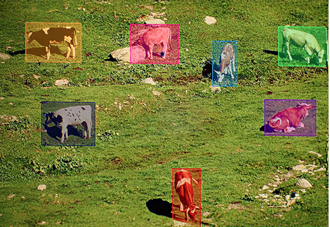
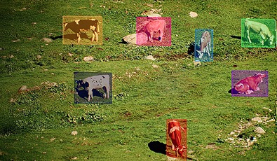
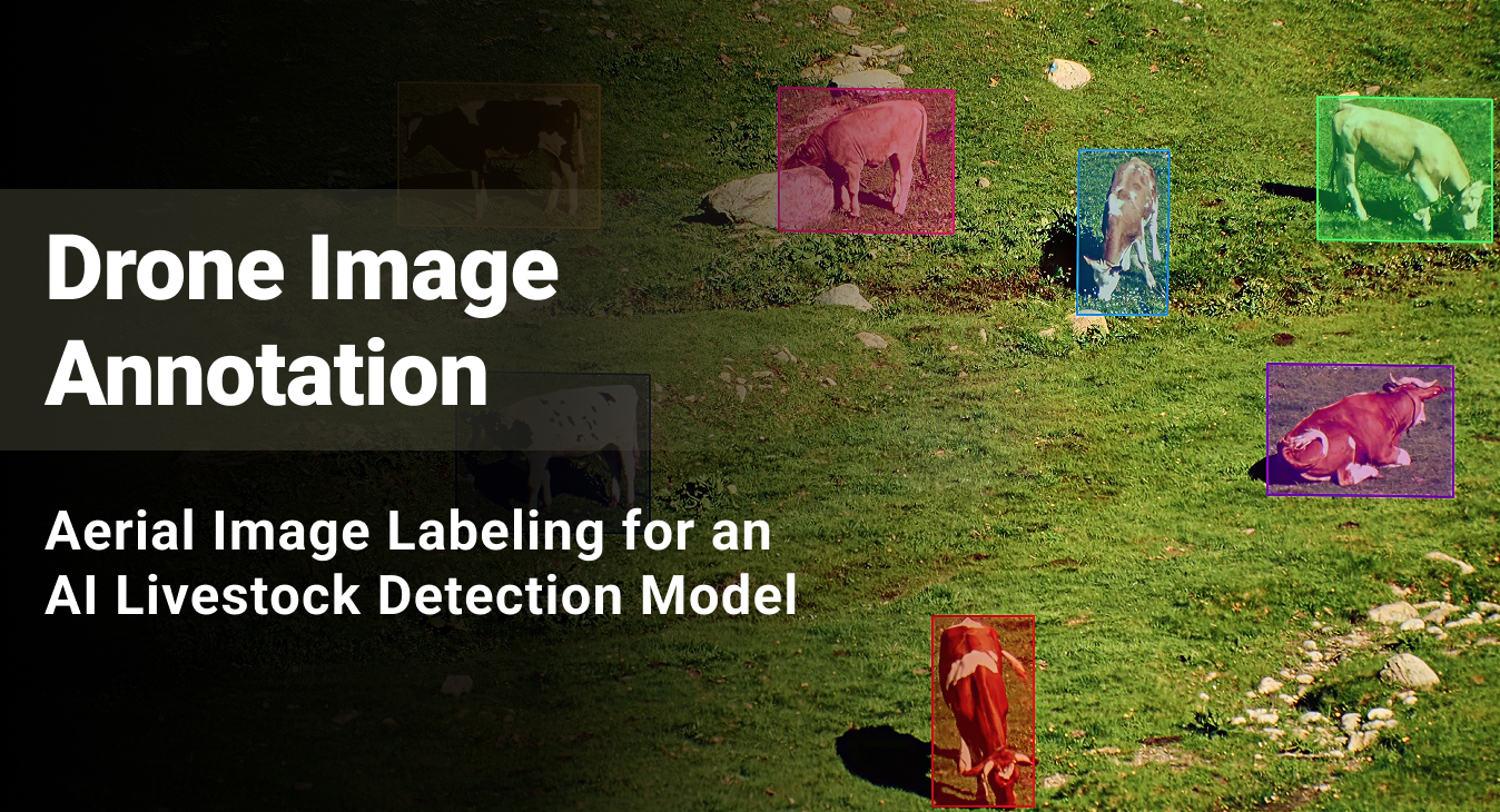
Labeled and validated over 10,000 high-resolution drone images monthly using QuPath to train an AI-powered livestock detection model, delivering 95%+ annotation accuracy.

10K+

Images Annotated Monthly

95%+

Labeling Accuracy
Bounding Box Annotation Services

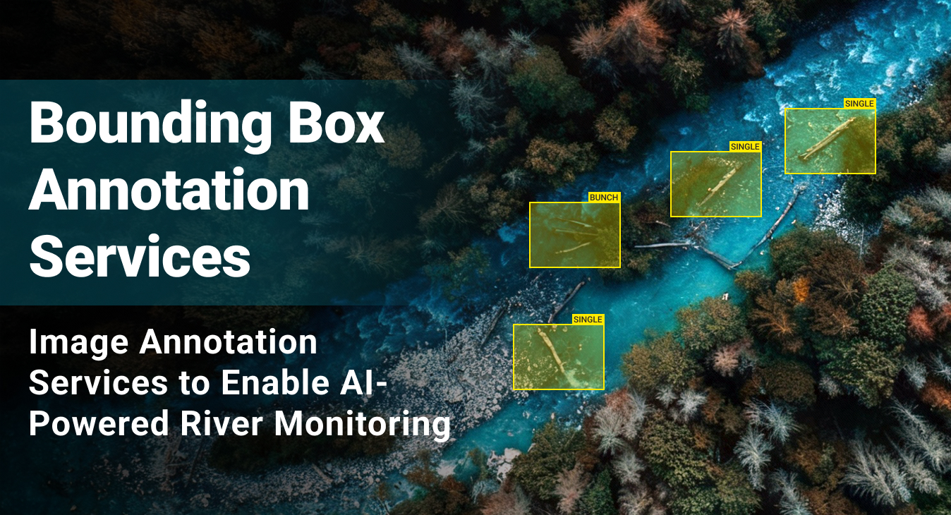
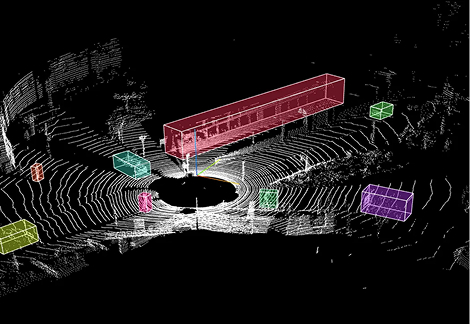
Precise bounding box annotation for high-resolution aerial river images to train an AI-powered river flow obstruction detection system using the client’s proprietary data annotation tool.

1,500 to 2,000

Images Labeled per Week

98%

Labeling Accuracy Rate Maintained

<1%

Revision/Rework Rate
  • Service Image Annotation
  • Platform Client’s Proprietary Annotation Platform
  • Industry Environmental Monitoring / Forestry
Aerial Image Annotation

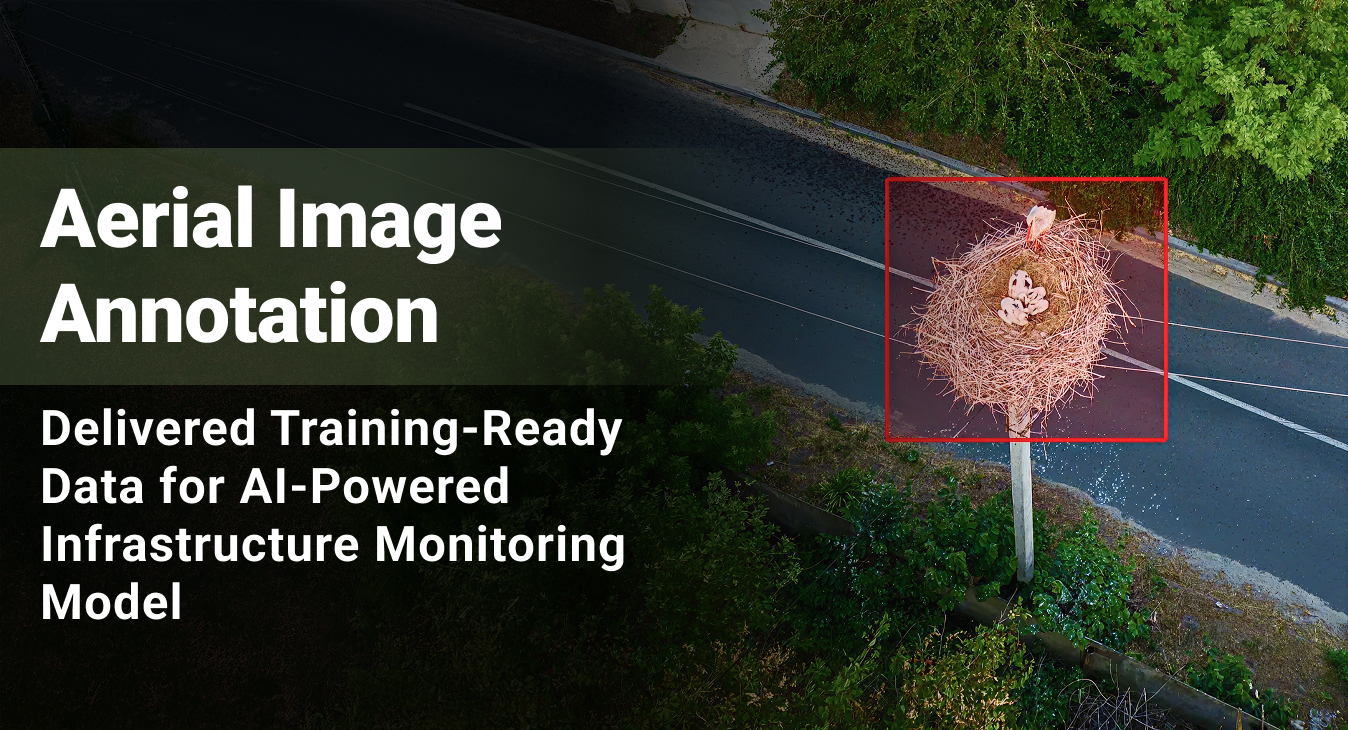
Large-scale image annotation services for a drone-based infrastructure monitoring company developing an automated bird nest detection system on power grids.

15,000+

Images Annotated

95%+

Annotation Accuracy
aerial image annotation

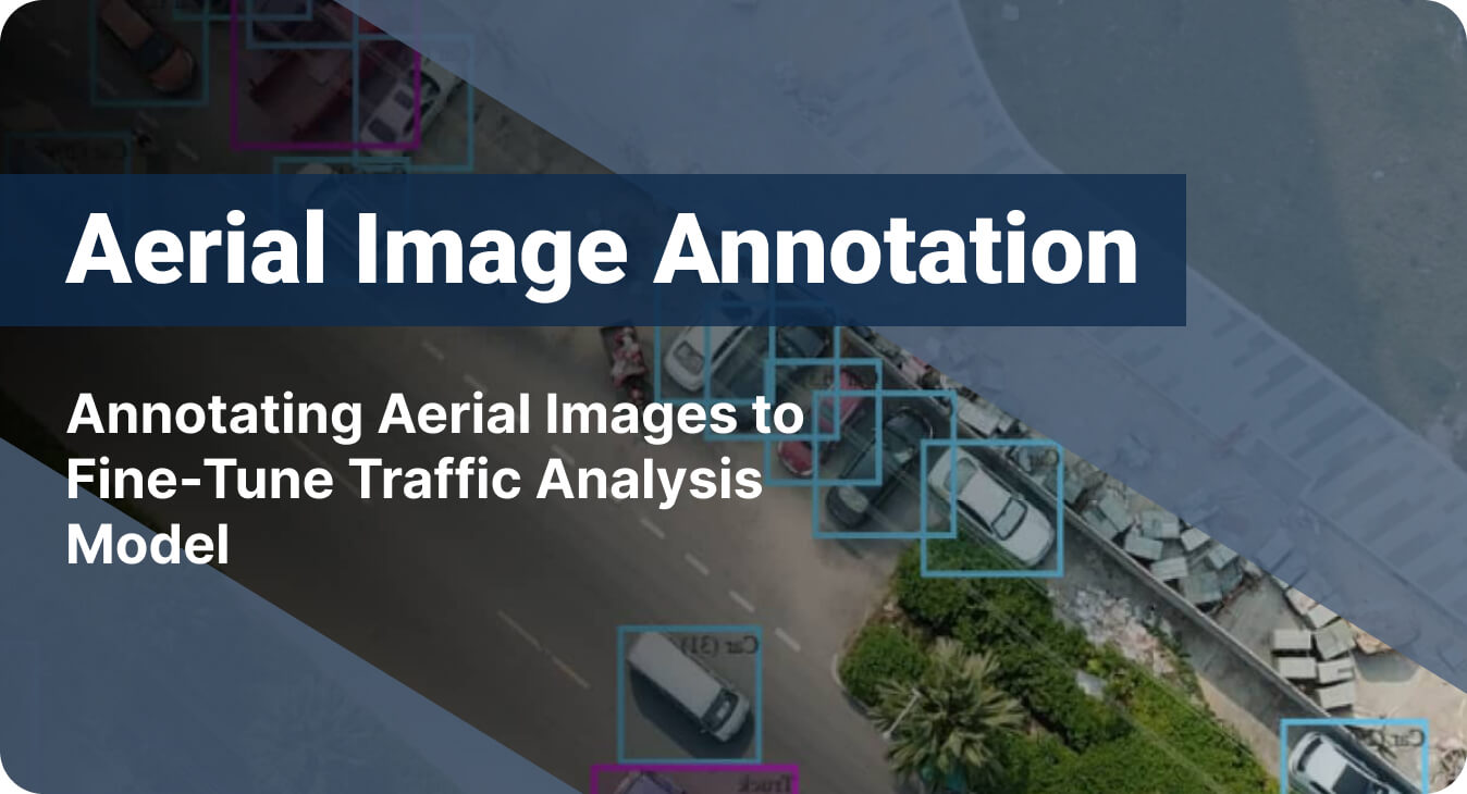
Helping a government agency improve urban traffic flow by boosting the accuracy of their AI system through aerial image labeling

35%

Increase in Model Accuracy

20%

Improvement in Traffic Flow Monitoring
 ai-model-snippet

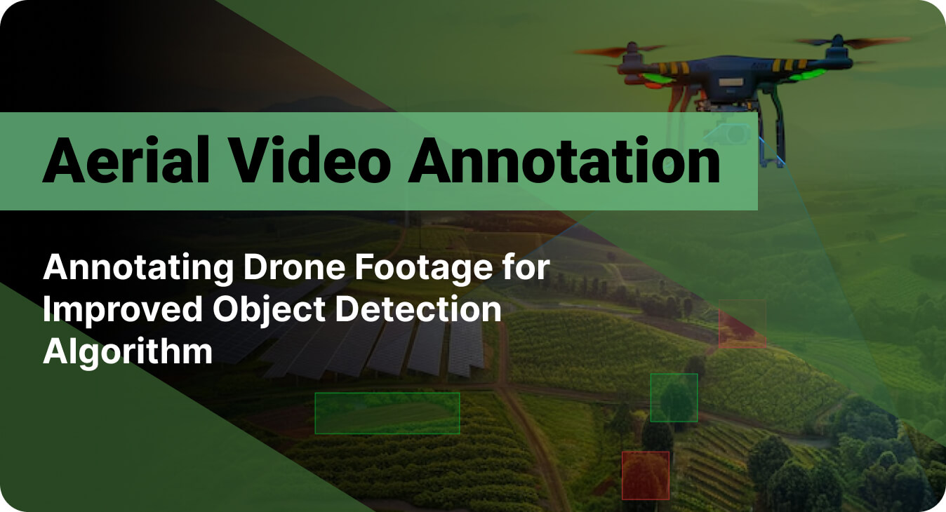
Labeled over 100,000 frames in drone footage to improve the accuracy of object detection algorithms used for drone surveillance

30%

Boost in Object Detection Accuracy

20%

Increase in Overall Operational Efficiency

Expanded

Drone Tracking Capabilities
  • Service Video Annotation Services Infrared & Thermal Imaging Processing Bounding Box Annotation
  • Platform CVAT
  • Industry Security and Surveillance
Data Labeling for a Predictive Content Intelligence Platform

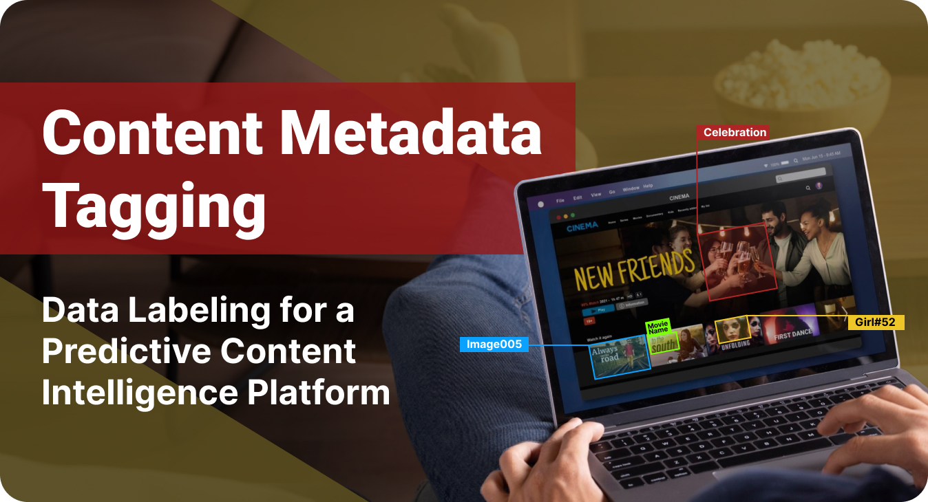
Labeled over 2500 entertainment content (Movies, TV Series, Trailers) monthly to enable the accurate prediction of the target audience engagement rates and response.

65%

Improved AI Model Accuracy

60%

Less Content Categorization Errors

4-Month

Faster Model Development

View All

Security and Compliance

Your data security is our priority

ISO
Certified

HIPAA
compliance

GDPR

GDPR
adherence

Regular
security audits

Encrypted data
transmission

Secure
cloud storage

CONTACT US

Start with a FREE Sample

Send us a sample dataset — or tell us what you need — and we'll annotate a sample batch at no cost. You can evaluate the quality, turnaround, and domain understanding, and only commit further if the outcomes align with your expectations.

FAQ - Frequently Asked Questions

AI Training Data for Agriculture

AI model validation services provide independent, expert-led testing that goes beyond standard performance metrics to assess whether your AI system will perform reliably, ethically, and safely in real-world conditions. Unlike internal testing (which verifies that the model learned your training data correctly) or automated CI/CD pipelines (which test code functionality), model validation services assess whether the AI’s decision-making logic is sound enough for production deployment with real users. We validate:

Yes. We offer both a free sample and a paid pilot — depending on how much validation you need before committing. If you want a quick read on output quality and annotation style, request a free sample and we'll process a small batch of your data so you can evaluate our work firsthand. If you want to validate the full workflow — tooling compatibility, delivery format, turnaround, and quality at scale — we can initiate a paid pilot that runs on your actual agricultural data within your real environment. That includes annotation, LLM fine-tuning, or AI model validation, depending on what your pipeline requires. Write to us at info@suntecindia.com to get started.

It happens — and in agriculture AI projects, it happens more often than in most other domains. When preparing AI training data for agtech solutions, we handle mid-project changes through a structured re-calibration process:

  • Update the annotation guidelines
  • Re-train affected annotators on the revised taxonomy
  • Run a fresh calibration exercise on sample data to verify consistency
  • Audit previously labeled data to determine whether re-annotation is needed or whether the existing labels can be mapped to the new schema

Our goal is to absorb the change without restarting the project and without letting revised labels introduce inconsistency with the training data you've already received.

Yes. We understand that Agricultural AI projects rarely have flat, predictable data volumes. When you need additional capacity, we onboard and calibrate new annotators within one to two weeks — including project-specific training, guideline review, sample annotation exercises, and accuracy benchmarking against your existing ground truth. This means new annotators enter production at the same quality standard as your current team.

All annotated datasets, raw data, and project-specific annotation guidelines developed during the engagement are the client’s intellectual property upon project completion. We do not retain copies, reuse client data to serve other clients, or repurpose your annotation guidelines for other projects.

Turnaround depends on dataset volume, annotation complexity (for example, bounding boxes are faster than pixel-level segmentation), number of label categories, and your QA requirements. We share a detailed project plan with milestone-level delivery dates before work begins, so you know exactly what to expect and when. We can also handle expedited timelines by structuring the team and workflow accordingly.

Our annotators are trained to flag ambiguous instances rather than guess the labels. Flagged cases are escalated to the project's QA lead, who either resolves them using the existing annotation guidelines or — if the case falls outside what the guidelines cover — routes them to your team for a definitive ruling. That ruling is then documented, added to the project's annotation guidelines as a new reference example, and communicated back to the full annotation team.

Yes. We regularly work with client-provided annotation platforms — whether that's your own Labelbox or CVAT instance, a proprietary internal tool, or any other environment your team has standardized on. We export annotated datasets in the format your ML pipeline requires — COCO, YOLO, Pascal VOC, or custom specifications — so your engineering team can ingest the data without additional conversion steps.

Yes. We source agricultural data from publicly available databases, such as PlantVillage, Radiant MLHub, USDA NASS, Copernicus Open Access Hub, and other open repositories — filtered by your specific requirements. If you also have proprietary data (drone captures, sensor feeds, field records), we integrate it with publicly sourced data to build a unified training dataset.