Geospatial AI Training Data Services

Geospatial Dataset Preparation Services for Satellite, Drone, and LiDAR Vision Models

For AI deployment in urban planning, supply chain logistics, environmental monitoring, and such geospatial AI use cases.

Get Your AI Training Data Proposal

Success Stories

...it's all about results

DRONE IMAGE ANNOTATION

DRONE IMAGE ANNOTATION

15K+ Drone Images Annotated with 95%+ Accuracy for Power Infrastructure Monitoring

Read More
Environmental Monitoring

AERIAL IMAGE ANNOTATION

2K+ High-Resolution Aerial Images Labeled with 98% Accuracy for Environmental Monitoring AI

Read More
SATELLITE DATA ANNOTATION

SATELLITE DATA ANNOTATION

8500+ Satellite Images Labeled with 98% Accuracy for Environmental Analysis Model

Read More

GEOSPATIAL AI TRAINING DATA SERVICES

Training Data Built for Remote Sensing and GIS Pipelines

Geospatial data is too complex for generic labelers who can’t distinguish between a building’s shadow and a newly paved asphalt road, or a rooftop solar panel and a skylight in high-altitude, often low-resolution drone, aerial, or satellite images. But unless you choose a specialized geospatial AI training data services provider, your machine learning engineers will be wasting half their sprint correcting mislabeled data.

SunTec India gives your team their time back.

We preprocess and label raw satellite images, aerial footage, and LiDAR point clouds. Our team includes subject matter experts and domain specialists to address geospatial data annotation challenges, such as uneven ground sample distance (GSD), camera tilt, shifting class definitions, and inconsistent coordinate metadata. We collect, prepare, annotate, fine-tune, and validate geospatial datasets against intended operating conditions. The result is stronger spatial accuracy, lower review burden, and a more dependable path to deployment.

Proven Domain Expertise

Hands-on experience with geospatial AI training data preparation, including satellite imagery annotation, georeferencing annotation, and GIS data labeling services.

Scale without Sacrificing Quality

Established operational workflows, in-house subject matter experts, and a large workforce with the flexibility to scale teams up or down based on your project's volume demands.

Security & Compliance

Your IP and proprietary datasets are protected at every stage with NDAs, strict internal access governance, data encryption, ISO, HIPAA, and GDPR compliance.

Flexible Engagement Models

Whether you need a short-term pilot (free sample available), a dedicated annotation team for an ongoing program, or burst capacity for a seasonal project, we configure the engagement to your requirements.

AI TRAINING DATA FOR GEOSPATIAL MODELS: SERVICES

How We Prepare Geospatial Training Data for Production Use

In geospatial AI, training data dictates what your model can actually achieve in production. If your training data has uneven label coverage across all geographic features within the footage, drifting label-class rules, or weak model validation datasets, your model will carry those flaws directly into deployment. The cost hits your bottom line immediately: unstable outputs, heavy analyst review burdens, delayed rollouts, and a loss of stakeholder trust. SunTec’s geospatial AI training data service fixes these dataset vulnerabilities before they impact model behavior. We combine AI-assisted pre-labeling, domain-aligned fine-tuning, validation against edge cases, and human-in-the-loop review to improve speed while maintaining annotation precision.

AI Data Collection Services

  • Gather high-quality satellite, aerial, drone, LiDAR, GIS, and terrain data from publicly available geospatial repositories and web-based spatial data sources.
  • Aggregate and integrate client-provided datasets, including imagery archives, vector layers, survey data, and area-of-interest captures, into the training pipeline alongside externally sourced data.
View MoreAI Data Collection Services

Data Preprocessing Services

  • Clean, normalize, and transform raw geospatial data into machine learning-ready formats.
  • Includes deduplication, format conversion (JSON, CSV, XML, COCO, YOLO, Pascal VOC), PII masking where applicable, geospatial data normalization, coordinate system tagging, georeferencing checks, and enrichment with metadata such as capture date, sensor type, resolution, and location context.
View MoreData Preprocessing Services

Geospatial Data Annotation Services

  • AI-assisted pre-annotation with expert human review across satellite imagery, aerial imagery, drone video, GIS layers, LiDAR point clouds, and terrain surfaces data, with annotation teams trained on project-specific rules, edge-case handling, and annotation accuracy up to 95-99%.
  • Teams that can work across prominent GIS data labeling tools, such as CVAT, Labelbox, Label Studio, and V7, as well as proprietary annotation platforms.
View MoreData Annotation Services

LLM Fine-Tuning Services

  • Supervised fine-tuning data (prompt-response pairs grounded in geospatial domain knowledge).
  • RLHF annotation to align model outputs with domain-specific expectations.
  • Adversarial red team testing to catch hallucinated outputs that could lead to safety incidents or operational failures.
View MoreLLM Fine-Tuning Services

AI Model Validation Services

  • Human-in-the-loop validation of your geospatial AI model's outputs.
  • Subject matter expert review to catch edge cases (boundary confusion, missed assets, class overlap, seasonal variance, and region-specific detection errors).
  • Bias audits to ensure your model performs across varying real-world conditions. Consensus-based accuracy checks with multi-annotator agreement metrics.
View MoreAI Model Validation Services

CLIENT SUCCESS STORIES

It's all about results.

The Proof is in the Pipeline

Discover how we’ve helped businesses across 50+ nations bridge the gap between "lab-ready" and "market-ready" AI/ML applications by solving their most complex training data challenges.

Aerial Image Annotation

Large-scale image annotation services for a drone-based infrastructure monitoring company developing an automated bird nest detection system on power grids.
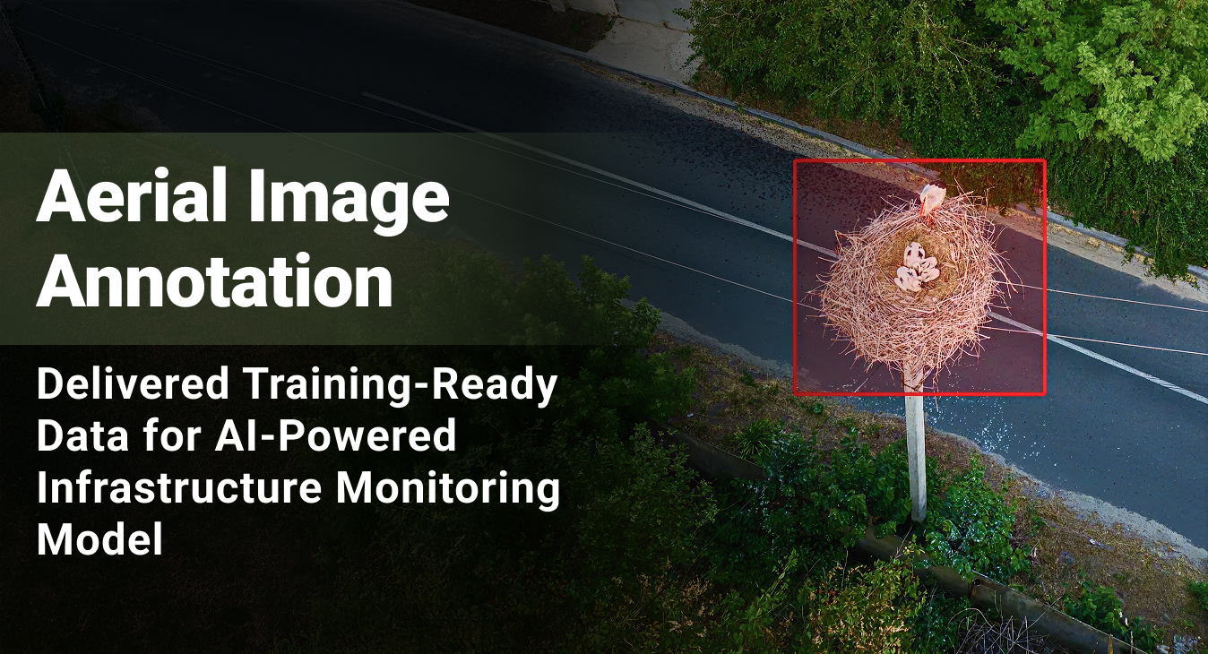
15,000+

Images Annotated

95%+

Annotation Accuracy
Image Segmentation

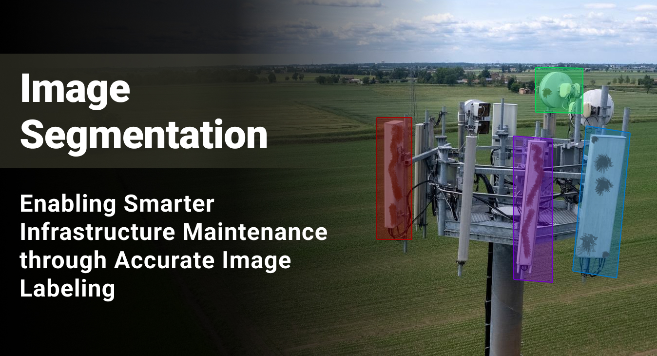
Image labeling and training data preparation to power an automated corrosion detection solution for an infrastructure digitization company.

99%

Inter-Annotator Consistency

25%

Improvement in Model Precision

95%+

Image Labeling Accuracy
Bounding Box Annotation Services

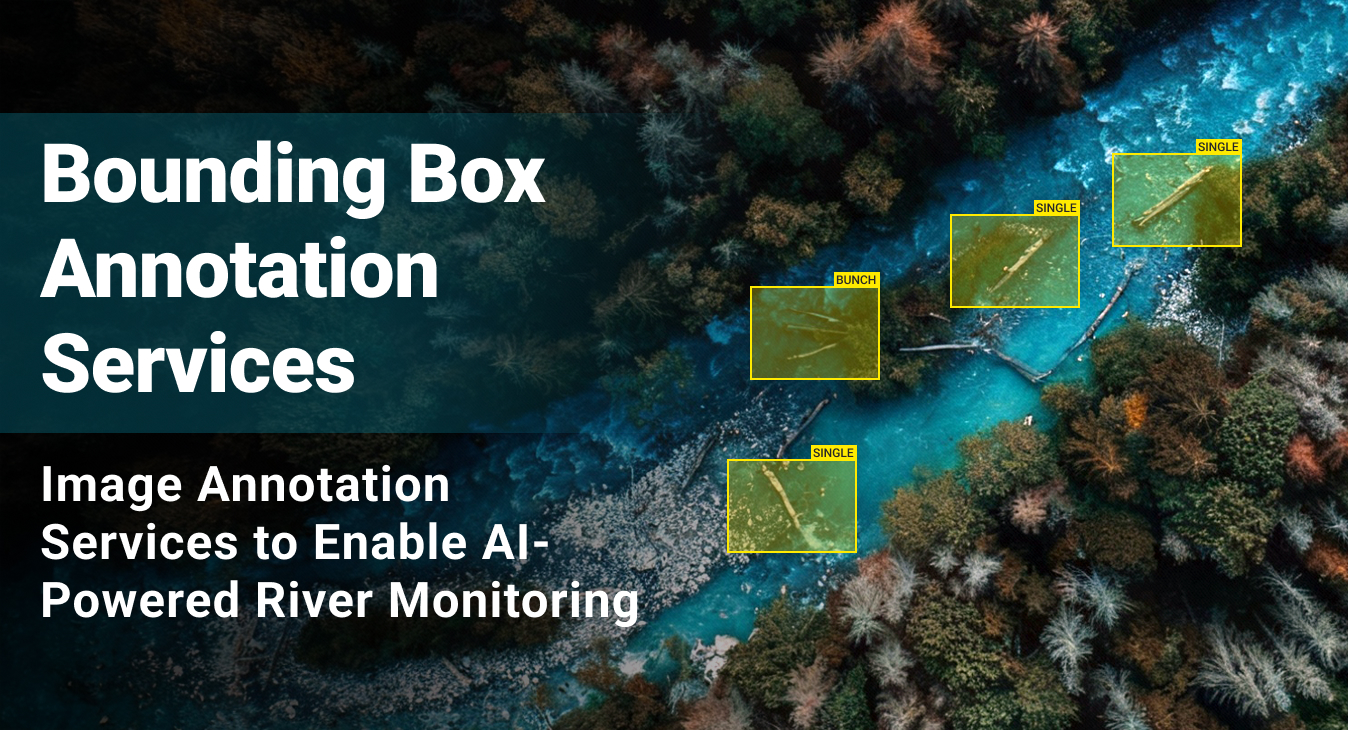
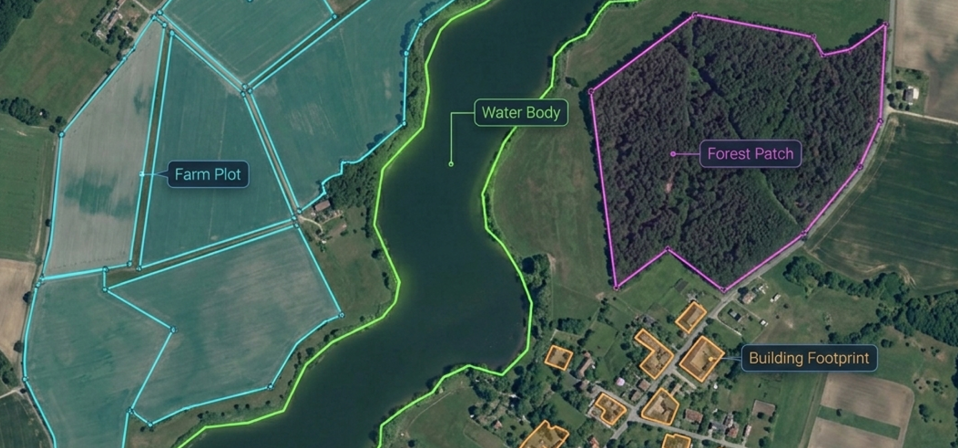
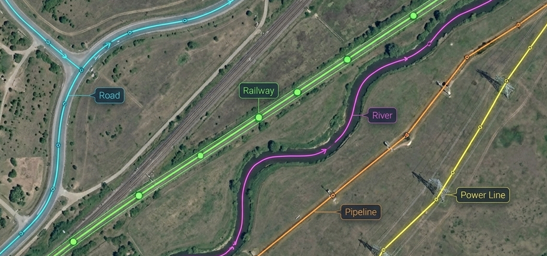
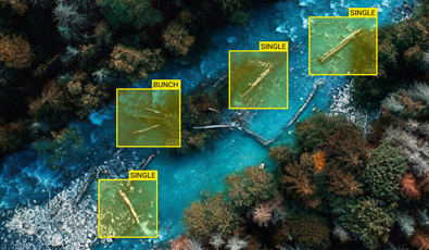
Precise bounding box annotation for high-resolution aerial river images to train an AI-powered river flow obstruction detection system using the client’s proprietary data annotation tool.

1,500 to 2,000

Images Labeled per Week

98%

Labeling Accuracy Rate Maintained

<1%

Revision/Rework Rate
  • Service Image Annotation
  • Platform Client’s Proprietary Annotation Platform
  • Industry Environmental Monitoring / Forestry
Semantic Segmentation

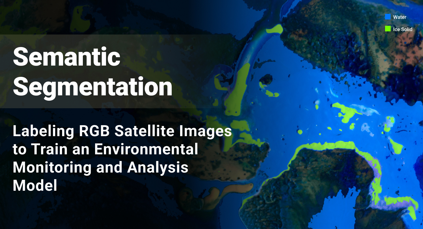
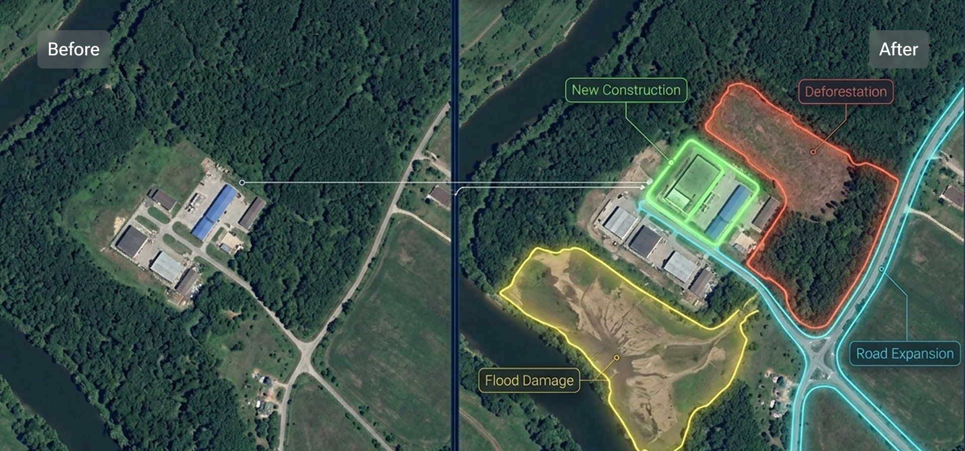
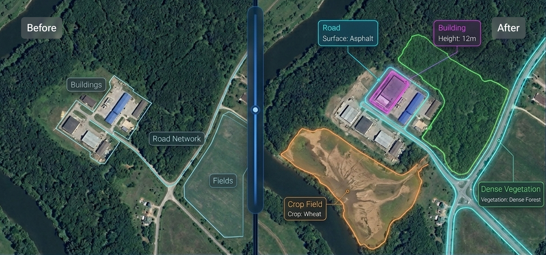
Helping a tech leader in the domain of Environmental Monitoring & Satellite Data Analysis train its AI model to identify and classify seasonal transitions in river bodies by annotating 8500+ images.

98%

Annotation Accuracy

99%

Client Acceptance Rate
  • Service Image Annotation
  • Platform CVAT
  • Industry Climate & Environmental Technology

View All

DATA ANNOTATION TYPES WE SUPPORT

The Geospatial Data Annotation Framework Powering Spatial Intelligence for Your AI Models

Geospatial AI shows up in many places. Land cover models map terrain at the continental scale. Detection systems spot vehicles, buildings, and infrastructure in satellite views. Change detection tracks deforestation, sprawl, and disaster damage over time. Routing models guide autonomous navigation from aerial imagery. Every model trains on different data and holds to a different accuracy bar — here's how our geospatial data annotation services deliver across the range.

Bounding Box Annotation

Drawing axis-aligned rectangles around features in satellite or drone imagery — vehicles, buildings, storage tanks — providing models with clear positions and rough sizes to detect.

Oriented Bounding Box Annotation

Drawing rotated rectangles that align with an object's actual orientation — fitting tilted ships, aircraft, vehicles, or solar panels more tightly than axis-aligned boxes allow.

Semantic Segmentation

Classifying every pixel in satellite or aerial imagery by land cover type — water, forest, cropland, built-up area — so models understand terrain at a granular level.

Instance Segmentation

Outlining each individual feature separately at the pixel level — not just "buildings" as a class, but each rooftop, vehicle, or storage tank as its own labeled instance.

Polygon Annotation

Tracing precise outlines around irregular geographic features — farm plots, water bodies, forest patches, or building footprints — where shape and boundary accuracy matter more than bounding area.

Polyline Annotation

Marking connected line segments along linear features — roads, railway tracks, rivers, pipelines, or power lines — capturing path geometry across aerial and satellite imagery.

Change Detection Annotation

Comparing two images of the same location taken at different times and labeling what has appeared, disappeared, or transformed — new construction, deforestation, or flood damage.

Attribute Annotation

Adding descriptive tags to already-labeled features — road surface type, building height, crop variety, or vegetation density — to enrich geospatial objects with context beyond shape alone.

Drawing axis-aligned rectangles around features in satellite or drone imagery — vehicles, buildings, storage tanks — providing models with clear positions and rough sizes to detect.

Drawing rotated rectangles that align with an object's actual orientation — fitting tilted ships, aircraft, vehicles, or solar panels more tightly than axis-aligned boxes allow.

Classifying every pixel in satellite or aerial imagery by land cover type — water, forest, cropland, built-up area — so models understand terrain at a granular level.

Outlining each individual feature separately at the pixel level — not just "buildings" as a class, but each rooftop, vehicle, or storage tank as its own labeled instance.

Tracing precise outlines around irregular geographic features — farm plots, water bodies, forest patches, or building footprints — where shape and boundary accuracy matter more than bounding area.

Marking connected line segments along linear features — roads, railway tracks, rivers, pipelines, or power lines — capturing path geometry across aerial and satellite imagery.

Comparing two images of the same location taken at different times and labeling what has appeared, disappeared, or transformed — new construction, deforestation, or flood damage.

Adding descriptive tags to already-labeled features — road surface type, building height, crop variety, or vegetation density — to enrich geospatial objects with context beyond shape alone.

TECH STACK

AI Data Services: Technology Stack

The Operational Stack Supporting Large-Scale AI Data Collection & Labeling

The infrastructure behind our AI data solutions is optimized for control and speed. This tech stack, implemented within our AI data preparation workflow, enables our AI training data services to remain predictable at scale, auditable under scrutiny, and dependable when models encounter real-world variability.

GEOSPATIAL AI TRAINING DATA SERVICES: USE CASES

Geospatial AI Training Data: Use Cases and Industry Applications We Serve

Different geospatial use cases require distinct annotation logic. A model built for urban infrastructure monitoring is judged on boundary precision, asset-state clarity, and change visibility, whereas a model built for disaster assessment is judged on speed, damage classification, and decision confidence. Our geospatial dataset preparation services are designed to align with the operational requirements of the client’s model development objectives.

Precision Agriculture & Ecosystem Monitoring

AI Capability

Classify land cover, separate crop types, trace field boundaries, and track seasonal change to support crop monitoring, farmland analysis, and ecosystem reporting.

Training Data Gap

These models usually fail when field edges shift between batches, crop stages are mixed, rare land classes receive too little representation in the training set, or seasonal imagery is compared without sufficient context.

Our Approach

We label time-series images to ensure field boundaries stay aligned as the landscape changes throughout the year. Strict annotation guidelines are drawn for marking borders around overlapping entities (crops and mixed vegetation) and hard-to-spot features (specific soil changes or unusual crop types). Reviewers then check difficult boundaries and seasonal drift before approval.

Urban Planning & Smart City Monitoring

AI Capability

Extract building footprints, map roads and utilities, and detect construction changes to support smart city mapping, urban infrastructure monitoring, and development tracking.

Training Data Gap

Urban infra AI models can fail when geospatial data annotation does not account for confusing cases (e.g., touching buildings merge into a single blob) or when spatial metadata fails to align (e.g., map coordinates do not perfectly match the underlying image).

Our Approach

Our geospatial dataset preparation services address edge cases (e.g., touching buildings, shadow-heavy footprints, incomplete road geometry, partial construction states). Annotators follow one labeling standard across batches, while reviewers inspect footprint separation, line continuity, and change states before release.

Route Detection, Mapping & Maintenance Planning

AI Capability

Detect road networks, rail lines, intersections, and transport corridors with enough geometric consistency to support mapping, maintenance planning, and route-level spatial intelligence.

Training Data Gap

Routing and mapping models can become confused if road classes are labeled inconsistently (due to poor image resolution, shifting camera angles that lead to overlapping or misaligned road lines, etc.).

Our Approach

We build the dataset as a connected network, not as isolated features on separate tiles. That means junction logic, segment continuity, road class, and surface detail are all defined before production starts. Annotators label according to that network logic, and reviewers closely inspect intersections, breaks, and edge transitions.

Vehicle Detection & Fleet Monitoring

AI Capability

Detect, classify, count, and track vehicles to support objectives, such as fleet monitoring, traffic analysis, parking intelligence, and activity estimation across overhead imagery and aerial video.

Training Data Gap

Performance degrades when small objects are marked with loose bounding boxes, the object's orientation is ignored, multiple objects appear merged in dense scenes, or vehicle classes lack sufficient hard training coverage across regions.

Our Approach

Our GIS data labeling services catch the level of detail your AI model needs to learn (count, broad vehicle class, or movement-level visibility). We draw tight, oriented bounding boxes (OBBs) that align perfectly with the object's actual direction and ensure pixel-level segmentation in crowded scenes. For video or time-series data, our QC team reviews your datasets frame by frame to verify that moving assets maintain perfect track continuity.

Autonomous Driving & Hazard Navigation

AI Capability

Enable vehicles to safely navigate complex environments by accurately detecting lane boundaries, road signs, pedestrians, and dynamic obstacles in real time, even in challenging weather conditions or dense urban traffic.

Training Data Gap

AV perception models struggle or fail when edge cases are poorly represented, such as unusual vehicle types, obscured traffic signals, erratic pedestrian behavior, or vision-blurring weather patterns like heavy snow or sudden glare.

Our Approach

Our geospatial data annotation services capture critical driving conditions, distinct environmental boundaries, and the precise intent of moving objects. Annotators use specific data labeling guidelines to tag 2D and 3D sensor data (including camera and LiDAR) for precise object detection, lane tracking, and behavioral cues, while expert reviewers verify that subtle or rare road anomalies are accurately classified, ensuring accurate vehicle reactions.

Water Resource & Marine Monitoring

AI Capability

Map water extent, shoreline change, water-quality conditions, and marine activity to support reservoir management, coastal monitoring, aquaculture analysis, and port intelligence.

Training Data Gap

Outputs weaken when water boundaries blur with shadows, seasonal extent is inconsistently labeled, spectral classes are oversimplified, or marine objects are reviewed without the surrounding water context.

Our Approach

We prepare the dataset around the hard parts first: mixed shorelines, sediment-heavy water, shadow interference, seasonal fluctuation, and object clutter near coasts or reservoirs. Annotators label with scene-level context rather than image-only judgments, and reviewers compare repeated captures to maintain stable water boundaries and condition classes over time.

Energy & Utility Infrastructure Defect Detection

AI Capability

To automatically find and monitor energy assets (like solar panels, wind turbines, and power lines), map long utility corridors, and track physical changes in infrastructure to help companies inspect equipment, plan grid expansions, and monitor emissions.

Training Data Gap

AI accuracy drops when annotators fail to label low-contrast components that merge into the background (transformers), add directional tags (labeling roads without north/south tags), create tight boundaries (marking circular structures with squares), or specify if assets are under construction or operational.

Our Approach

We customize the labeling geometry and rules to match the exact shape and function of each asset before large-scale annotation begins. Reviewers then audit the data for geometric accuracy, network continuity, and transition stages to ensure the AI can reliably isolate low-contrast components and track development over time.

Climate Change & Environmental Monitoring

AI Capability

Track deforestation, land degradation, habitat transformation, and long-term ecosystem shifts to support global climate reporting, localized conservation planning, and corporate ESG (Environmental, Social, and Governance) compliance.

Training Data Gap

Old and new satellite images differ greatly in quality, making standardized labeling guidelines unreliable. The gap widens when labels don't account for natural seasonal variation, changes happening over time, or poorly separated areas in any footage.

Our Approach

We fix ecological classes, baseline definitions, and change criteria early so labels stay meaningful across dates, regions, and archived imagery. Annotators work against that environmental logic from the first batch. Reviewers compare older and newer imagery against the same environmental logic before approval.

Disaster Impact Assessment & Infrastructure Mapping

AI Capability

Assess post-event building damage, blocked routes, infrastructure losses, and service disruptions quickly enough to support emergency response and recovery prioritization.

Training Data Gap

HADR (Humanitarian Assistance and Disaster Response) models fail when pre- and post-disaster images are misaligned, damage classes are applied inconsistently, or urgent labeling deadlines cause annotators to miss subtle infrastructure failures, like a tiny crack in a dam.

Our Approach

We define what counts as structural loss, blocked access, debris spread, and ordinary change before labeling begins. Annotators compare pre- and post-event context side by side, instead of judging damage from one scene alone. Reviewers then verify debris, route blockage, and structure-loss logic before release.

Waste Management & Pollution Monitoring

AI Capability

Detects illegal dump sites, landfill expansion, floating waste, and waste-type patterns to support pollution detection, cleanup planning, and environmental compliance monitoring.

Training Data Gap

Waste boundaries, captured from a high-altitude drone or satellite, can look confusing (light-colored trash can easily mimic dry, rocky soil). The model must also be trained to identify changes over time with regional context (such as differentiating a tropical-region waste dump from a desert waste site).

Our Approach

We build the labeling logic around the distinction that matters most here: what is actual waste, what only looks similar to waste, and when site growth is meaningful enough to mark. Annotators work from region-specific examples rather than broad visual assumptions, and reviewers compare site context, surrounding land use, and time-based changes before approval.

Terrain Elevation Modeling (LiDAR & 3D Spatial Data Labeling)

AI Capability

Classify terrain, structures, vegetation, and elevation features to support surface modeling for AI applications such as flood risk assessment, long-distance infrastructure planning, and carbon accounting.

Training Data Gap

3D data naturally comes with noise, but the AI model needs to differentiate at a very granular level, such as actual dirt (ground) and things sitting on the dirt (grass, bushes, rocks). Typical challenges include drifting vertical classes, unflagged noisy elements, or inconsistent geometric labeling.

Our Approach

We define class logic for ground, structure, vegetation, and artifacts before labeling begins (e.g., "Any manicured lawn or ground vegetation under 15 centimeters must be classified directly as Ground, while anything taller becomes Low Vegetation."). Annotators use 3D annotation tools for point cloud labeling, and reviewers check separations, vertical confusion, and artifact-heavy zones before approval.

Environmental Risk & Disaster Prediction

AI Capability

Predict flood, wildfire, drought, or landslide risk by learning from terrain, moisture, vegetation stress, and multi-date environmental signals before events escalate.

Training Data Gap

Risk models degrade when event labels are inconsistent, terrain context is underused, temporal progression is poorly represented, or rare hazard conditions are absent from the training data.

Our Approach

We shape the dataset around what your product must recognize as early risk evidence, what belongs in the background, and when progression is meaningful enough to mark. Annotators work according to defined rules for terrain-linked signals, severity cues, and time-series progression, while reviewers assess whether changes reflect real event development or ordinary environmental variation.

AI Capability

Classify land cover, separate crop types, trace field boundaries, and track seasonal change to support crop monitoring, farmland analysis, and ecosystem reporting.

Training Data Gap

These models usually fail when field edges shift between batches, crop stages are mixed, rare land classes receive too little representation in the training set, or seasonal imagery is compared without sufficient context.

Our Approach

We label time-series images to ensure field boundaries stay aligned as the landscape changes throughout the year. Strict annotation guidelines are drawn for marking borders around overlapping entities (crops and mixed vegetation) and hard-to-spot features (specific soil changes or unusual crop types). Reviewers then check difficult boundaries and seasonal drift before approval.

AI Capability

Extract building footprints, map roads and utilities, and detect construction changes to support smart city mapping, urban infrastructure monitoring, and development tracking.

Training Data Gap

Urban infra AI models can fail when geospatial data annotation does not account for confusing cases (e.g., touching buildings merge into a single blob) or when spatial metadata fails to align (e.g., map coordinates do not perfectly match the underlying image).

Our Approach

Our geospatial dataset preparation services address edge cases (e.g., touching buildings, shadow-heavy footprints, incomplete road geometry, partial construction states). Annotators follow one labeling standard across batches, while reviewers inspect footprint separation, line continuity, and change states before release.

AI Capability

Detect road networks, rail lines, intersections, and transport corridors with enough geometric consistency to support mapping, maintenance planning, and route-level spatial intelligence.

Training Data Gap

Routing and mapping models can become confused if road classes are labeled inconsistently (due to poor image resolution, shifting camera angles that lead to overlapping or misaligned road lines, etc.).

Our Approach

We build the dataset as a connected network, not as isolated features on separate tiles. That means junction logic, segment continuity, road class, and surface detail are all defined before production starts. Annotators label according to that network logic, and reviewers closely inspect intersections, breaks, and edge transitions.

AI Capability

Detect, classify, count, and track vehicles to support objectives, such as fleet monitoring, traffic analysis, parking intelligence, and activity estimation across overhead imagery and aerial video.

Training Data Gap

Performance degrades when small objects are marked with loose bounding boxes, the object's orientation is ignored, multiple objects appear merged in dense scenes, or vehicle classes lack sufficient hard training coverage across regions.

Our Approach

Our GIS data labeling services catch the level of detail your AI model needs to learn (count, broad vehicle class, or movement-level visibility). We draw tight, oriented bounding boxes (OBBs) that align perfectly with the object's actual direction and ensure pixel-level segmentation in crowded scenes. For video or time-series data, our QC team reviews your datasets frame by frame to verify that moving assets maintain perfect track continuity.

AI Capability

Enable vehicles to safely navigate complex environments by accurately detecting lane boundaries, road signs, pedestrians, and dynamic obstacles in real time, even in challenging weather conditions or dense urban traffic.

Training Data Gap

AV perception models struggle or fail when edge cases are poorly represented, such as unusual vehicle types, obscured traffic signals, erratic pedestrian behavior, or vision-blurring weather patterns like heavy snow or sudden glare.

Our Approach

Our geospatial data annotation services capture critical driving conditions, distinct environmental boundaries, and the precise intent of moving objects. Annotators use specific data labeling guidelines to tag 2D and 3D sensor data (including camera and LiDAR) for precise object detection, lane tracking, and behavioral cues, while expert reviewers verify that subtle or rare road anomalies are accurately classified, ensuring accurate vehicle reactions.

AI Capability

Map water extent, shoreline change, water-quality conditions, and marine activity to support reservoir management, coastal monitoring, aquaculture analysis, and port intelligence.

Training Data Gap

Outputs weaken when water boundaries blur with shadows, seasonal extent is inconsistently labeled, spectral classes are oversimplified, or marine objects are reviewed without the surrounding water context.

Our Approach

We prepare the dataset around the hard parts first: mixed shorelines, sediment-heavy water, shadow interference, seasonal fluctuation, and object clutter near coasts or reservoirs. Annotators label with scene-level context rather than image-only judgments, and reviewers compare repeated captures to maintain stable water boundaries and condition classes over time.

AI Capability

To automatically find and monitor energy assets (like solar panels, wind turbines, and power lines), map long utility corridors, and track physical changes in infrastructure to help companies inspect equipment, plan grid expansions, and monitor emissions.

Training Data Gap

AI accuracy drops when annotators fail to label low-contrast components that merge into the background (transformers), add directional tags (labeling roads without north/south tags), create tight boundaries (marking circular structures with squares), or specify if assets are under construction or operational.

Our Approach

We customize the labeling geometry and rules to match the exact shape and function of each asset before large-scale annotation begins. Reviewers then audit the data for geometric accuracy, network continuity, and transition stages to ensure the AI can reliably isolate low-contrast components and track development over time.

AI Capability

Track deforestation, land degradation, habitat transformation, and long-term ecosystem shifts to support global climate reporting, localized conservation planning, and corporate ESG (Environmental, Social, and Governance) compliance.

Training Data Gap

Old and new satellite images differ greatly in quality, making standardized labeling guidelines unreliable. The gap widens when labels don't account for natural seasonal variation, changes happening over time, or poorly separated areas in any footage.

Our Approach

We fix ecological classes, baseline definitions, and change criteria early so labels stay meaningful across dates, regions, and archived imagery. Annotators work against that environmental logic from the first batch. Reviewers compare older and newer imagery against the same environmental logic before approval.

AI Capability

Assess post-event building damage, blocked routes, infrastructure losses, and service disruptions quickly enough to support emergency response and recovery prioritization.

Training Data Gap

HADR (Humanitarian Assistance and Disaster Response) models fail when pre- and post-disaster images are misaligned, damage classes are applied inconsistently, or urgent labeling deadlines cause annotators to miss subtle infrastructure failures, like a tiny crack in a dam.

Our Approach

We define what counts as structural loss, blocked access, debris spread, and ordinary change before labeling begins. Annotators compare pre- and post-event context side by side, instead of judging damage from one scene alone. Reviewers then verify debris, route blockage, and structure-loss logic before release.

AI Capability

Detects illegal dump sites, landfill expansion, floating waste, and waste-type patterns to support pollution detection, cleanup planning, and environmental compliance monitoring.

Training Data Gap

Waste boundaries, captured from a high-altitude drone or satellite, can look confusing (light-colored trash can easily mimic dry, rocky soil). The model must also be trained to identify changes over time with regional context (such as differentiating a tropical-region waste dump from a desert waste site).

Our Approach

We build the labeling logic around the distinction that matters most here: what is actual waste, what only looks similar to waste, and when site growth is meaningful enough to mark. Annotators work from region-specific examples rather than broad visual assumptions, and reviewers compare site context, surrounding land use, and time-based changes before approval.

AI Capability

Classify terrain, structures, vegetation, and elevation features to support surface modeling for AI applications such as flood risk assessment, long-distance infrastructure planning, and carbon accounting.

Training Data Gap

3D data naturally comes with noise, but the AI model needs to differentiate at a very granular level, such as actual dirt (ground) and things sitting on the dirt (grass, bushes, rocks). Typical challenges include drifting vertical classes, unflagged noisy elements, or inconsistent geometric labeling.

Our Approach

We define class logic for ground, structure, vegetation, and artifacts before labeling begins (e.g., "Any manicured lawn or ground vegetation under 15 centimeters must be classified directly as Ground, while anything taller becomes Low Vegetation."). Annotators use 3D annotation tools for point cloud labeling, and reviewers check separations, vertical confusion, and artifact-heavy zones before approval.

AI Capability

Predict flood, wildfire, drought, or landslide risk by learning from terrain, moisture, vegetation stress, and multi-date environmental signals before events escalate.

Training Data Gap

Risk models degrade when event labels are inconsistent, terrain context is underused, temporal progression is poorly represented, or rare hazard conditions are absent from the training data.

Our Approach

We shape the dataset around what your product must recognize as early risk evidence, what belongs in the background, and when progression is meaningful enough to mark. Annotators work according to defined rules for terrain-linked signals, severity cues, and time-series progression, while reviewers assess whether changes reflect real event development or ordinary environmental variation.

Security and Compliance

Your data security is our priority

ISO
Certified

HIPAA
compliance

GDPR

GDPR
adherence

Regular
security audits

Encrypted data
transmission

Secure
cloud storage

CONTACT US

Need a Reliable Geospatial AI Training Data Provider?

Scale your geospatial vision model with SunTec India - get the right AI datasets for geospatial analysis, customized as per your model’s intended behavior. Request a free sample of geospatial data annotation services through the same production workflow, QA controls, and geospatially trained team we use on actual projects. You can review the labeled training dataset, evaluate annotation precision, QA discipline, and delivery fit against your own standards, and decide if we are the right fit for your requirements.

FAQ - Frequently Asked Questions

AI Training Data Services for Geospatial Models

Our GIS data labeling services initiate with a structured onboarding and calibration process. We develop project-specific annotation guidelines with your team, covering class definitions, boundary rules, coordinate reference requirements, georeferencing checks, and edge-case handling guidelines. Our annotators then complete calibration exercises on sample data, and their outputs are benchmarked against expert-reviewed ground truth before production begins. Only teams that meet accuracy thresholds of 95-99% move to production work. Once the project goes live, our QA leads run ongoing quality reviews, inter-annotator agreement checks, and recalibration cycles as the dataset evolves. This helps maintain annotation quality across the full delivery lifecycle.

Yes. We offer both a free sample and a paid pilot, depending on how much validation you need before scaling. If you want a quick review of output quality, annotation precision, or dataset structure, we can process a small batch of your AI training dataset so you can evaluate our work directly. If you want to validate the full workflow — tooling compatibility, delivery format, turnaround, and quality at scale — we can run a paid pilot in your environment. That includes annotation, LLM fine-tuning, or AI model validation, depending on your requirements. Write to us at info@suntecindia.com to get started.

We handle mid-project changes when labeling AI datasets for geospatial analysis through a structured recalibration process:

  • Update the annotation guidelines
  • Re-train affected annotators on the revised taxonomy
  • Run a fresh calibration exercise on sample data to verify consistency
  • Audit previously labeled data to determine whether re-annotation is needed or whether the existing labels can be mapped to the new schema

Our goal is to absorb the change without restarting the project or introducing inconsistencies within the labeled GIS & mapping data you've already received.

Yes. When data volume increases, we scale labeling and training data preparation capacity through a structured onboarding process that includes project-specific training, guideline review, sample annotation exercises, and quality benchmarking against your approved ground truth. This ensures that new annotators enter production at the same quality standard as your current team.

All annotated datasets, raw data, project-specific annotation guidelines, and review frameworks developed during the engagement remain the client’s intellectual property after project completion. We do not retain copies, reuse your data for other clients, or repurpose your project-specific logic for other engagements.

The turnaround time for geospatial AI training data services depends on dataset volume, annotation complexity, the number of label classes, and QA requirements. Before work begins, we share a detailed project plan with milestone-level delivery dates so you know what to expect and when. If you need a faster turnaround, we can structure the team and workflow accordingly without compromising quality.

Our annotators are trained to flag ambiguous instances rather than guess. Flagged cases are escalated to the project QA lead, who reviews them against the current annotation guidelines. If the case falls outside the defined rules, it is routed to your team for a final decision. That decision is then documented, added to the guideline set as a reference example, and shared across the full annotation team.

Yes. We regularly work within client-provided environments, whether that is Labelbox, CVAT, Label Studio, a proprietary internal platform, or another setup your team has standardized on. We also deliver datasets in the format your ML pipeline requires — COCO, YOLO, Pascal VOC, JSON, CSV, or custom formats — so your engineering and machine learning teams can ingest the output without extra conversion steps.

Yes. Our geospatial dataset preparation services are designed to close training data gaps by sourcing, filtering, and assembling datasets tailored to your model’s exact use case. Depending on fit, that may include satellite imagery, aerial captures, GIS & mapping data, LiDAR & 3D spatial data, map feature extraction datasets, etc. We can also combine them with your proprietary geospatial data, then clean, standardize, and structure the final dataset for annotation, fine-tuning, or validation.

You get structured visibility throughout the engagement, including batch-level throughput, edge-case and exception logs, inter-annotator agreement trends, revision counts, and QA findings tied to specific delivery batches. We set the reporting cadence during onboarding — daily, weekly, or milestone-based — depending on project scale and your internal review cycle. Your team can get an overview of where label consistency is improving, where defect logic is creating review friction, and where additional calibration may be needed before those issues affect training or validation.