AI Training Data Services for Autonomous Vehicles

Helping Automakers and Automotive Tech Suppliers (Drone Fleets, Industrial Robotics) Build Reliable Driverless Mobility Solutions

Camera, LiDAR, radar, ultrasonic — every sensor modality your AV solution consumes — processed, annotated, and validated through one human-in-the-loop pipeline.

Get Your AI Training Data Proposal

Success Stories

...it's all about results

SECURITY & SURVEILLANCE

SECURITY & SURVEILLANCE

30% Improved Object Detection Accuracy Through High-Precision Drone Video Labeling

Read More
SMART CITY INFRASTRUCTURE

SMART CITY INFRASTRUCTURE

35% Better Object Detection Accuracy for an AI Traffic Analysis Model

Read More
POWER GRID INFRASTRUCTURE

POWER GRID INFRASTRUCTURE

Drone Image Annotation with 95%+ Accuracy for Bird Nest Detection on Power Infrastructure

Read More

AI TRAINING DATA SERVICES FOR AUTONOMOUS VEHICLES

Eliminate Model Noise with Accurate AV Data Annotation & Training Data Preparation

Autonomous mobility systems must be trained precisely on everyday scenarios (traffic, pedestrians crossing, animals on the road, complicated warehouse routes, vegetation over landscapes) as well as high-consequence scenarios (a pedestrian stepping out from behind a parked truck, navigating hairpin bends in a torrential storm, or sun-glare illusions on a tarmac) to perform reliably. SunTec India ensures that through end-to-end AI training data services for autonomous vehicles.

Objects, lane boundaries, and dynamic actors are tracked temporally across sequential frames to preserve accurate velocity and trajectory vectors. Through multi-tiered Human-in-the-Loop (HITL) validation, we enforce 95-99% annotation accuracy, eliminating data noise that causes real-time model regression.

Proven Domain Expertise

Hands-on experience with autonomous vehicle AI training data preparation — multi-sensor data processing, 2D and 3D annotation across camera and LiDAR modalities, ADAS-specific labeling.

Scale without Sacrificing Quality

Established operational workflows, in-house subject matter experts, and a large workforce with the flexibility to scale teams up or down based on your project's annotation volume and deployment timeline.

Security & Compliance

Your proprietary sensor data and AV datasets are protected at every stage through NDAs, strict internal access governance, data encryption, and ISO and GDPR compliance.

Flexible Engagement Models

Whether you need a short-term pilot (a free sample is available), a dedicated annotation team for an ongoing program, or burst capacity for a seasonal project, we tailor the engagement to your requirements.

AI TRAINING DATA SERVICES FOR AUTONOMOUS VEHICLES: SERVICES

Training Data Services for AV Perception, Navigation, and Decision-Making

AV training data pipelines are fundamentally sequential—data degradation at any stage carries a compounding penalty downstream. Preprocessing choices shape annotation quality. Annotation taxonomy determines what validation can and cannot measure. When these stages operate within disconnected teams with disconnected logic, the inconsistencies do not cancel each other out; they compound. SunTec India eliminates this systemic risk by unifying the training data lifecycle. Our AI training data services for autonomous vehicles are built as a single connected operation—shared labeling logic, shared taxonomy, and a single quality framework from sensor ingestion to deployment-ready delivery—to support reliable driverless mobility solutions.

AI Data Collection Services

  • Gather high-quality images, videos, GPS coordinates, and such data from public autonomous driving databases and web-based automotive data sources.
  • Aggregate and integrate client-provided datasets (Dashcam recordings, test track captures, simulation exports, sensor logs) into the training pipeline alongside externally sourced data.
View MoreAI Data Collection Services

Data Preprocessing Services

  • Clean, normalize, and transform raw autonomous-vehicle sensor data into machine-learning-ready formats.
  • Includes deduplication, format conversion (JSON, CSV, XML, COCO, YOLO, Pascal VOC), PII masking where applicable, and enrichment with external metadata like road type classification, weather condition tags, geographic context, etc.
View MoreData Preprocessing Services

Data Annotation Services

  • AI-assisted pre-annotation with expert human review across images, video, LiDAR point clouds, and radar streams — with annotation teams trained on product-specific guidelines.
  • Relevant edge-case handling with annotation accuracy up to 95-99%.
  • Teams that work natively across prominent data labeling tools, such as CVAT, Labelbox, Label Studio, and V7, as well as client-proprietary annotation platforms.
View MoreData Annotation Services

LLM Fine-Tuning Services

  • Supervised fine-tuning data (prompt-response pairs grounded in your product's domain knowledge).
  • RLHF annotation to align model outputs with domain-specific expectations, safety-critical communication standards, and human preferences.
  • Adversarial red team testing to catch hallucinated responses that could lead to safety or regulatory issues.
View MoreLLM Fine-Tuning Services

AI Model Validation Services

  • Human-in-the-loop validation of your autonomous vehicle AI model's outputs.
  • Subject matter expert review to catch edge cases (misclassified objects in adverse weather, undetected lane boundaries, false-positive obstacle detections).
  • Bias audits to ensure your model performs across varying real-world conditions. Consensus-based accuracy checks with multi-annotator agreement protocols.
View MoreAI Model Validation Services

CLIENT SUCCESS STORIES

It's all about results.

The Proof is in the Pipeline

Discover how we’ve helped businesses across 50+ nations bridge the gap between "lab-ready" and "market-ready" AI/ML applications by solving their most complex training data challenges.

 ai-model-snippet

Labeled over 100,000 frames in drone footage to improve the accuracy of object detection algorithms used for drone surveillance
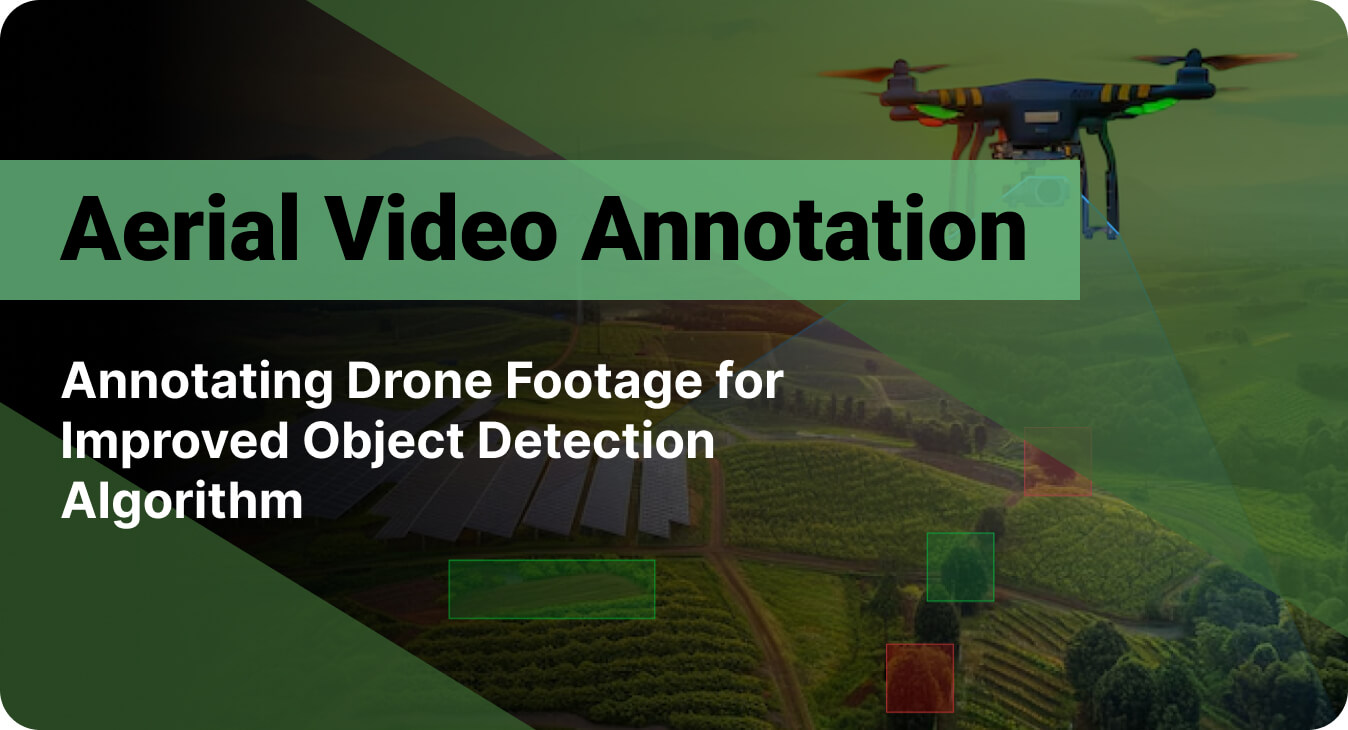
30%

Boost in Object Detection Accuracy

20%

Increase in Overall Operational Efficiency

Expanded

Drone Tracking Capabilities
  • Service Video Annotation Services Infrared & Thermal Imaging Processing Bounding Box Annotation
  • Platform CVAT
  • Industry Security and Surveillance
aerial image annotation

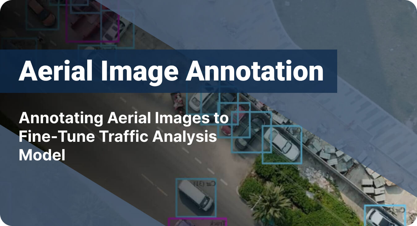
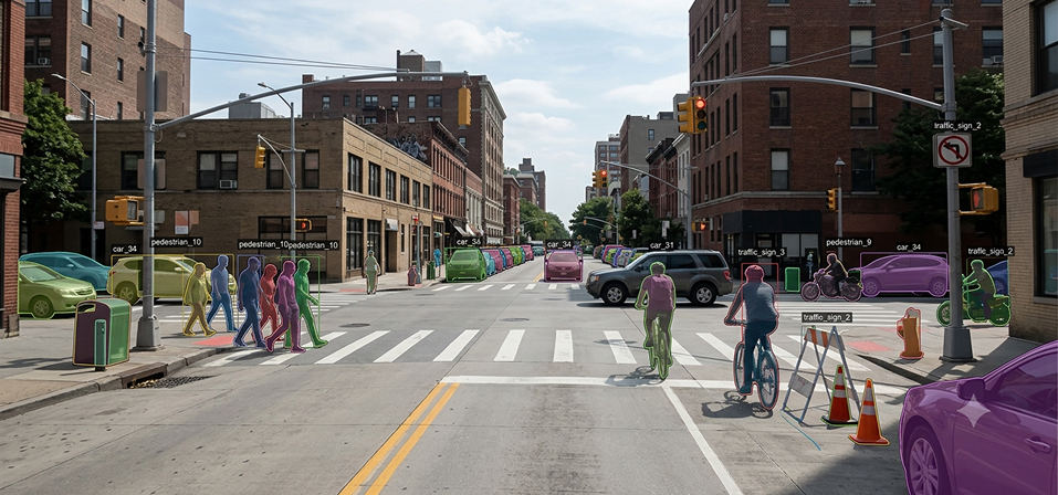
Helping a government agency improve urban traffic flow by boosting the accuracy of their AI system through aerial image labeling

35%

Increase in Model Accuracy

20%

Improvement in Traffic Flow Monitoring
Aerial Image Annotation

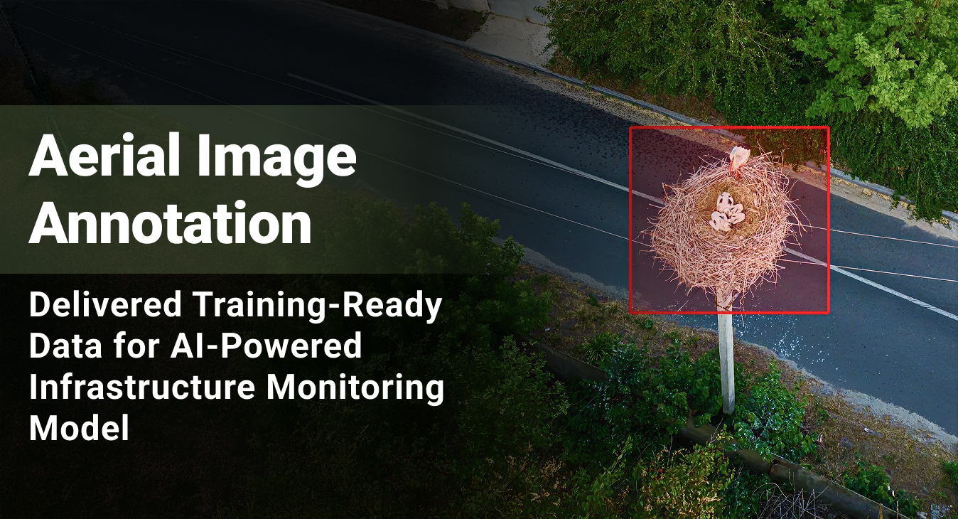
Large-scale image annotation services for a drone-based infrastructure monitoring company developing an automated bird nest detection system on power grids.

15,000+

Images Annotated

95%+

Annotation Accuracy

View All

AUTONOMOUS VEHICLE DATA ANNOTATION TYPES WE SUPPORT

Annotation Built for Every Platform that Has to Sense, Predict, and Move

An autonomous vehicle's software stack relies on a precise understanding of the road: detecting objects, predicting their behavior, and planning a safe route forward. If your training data is inaccurate or misaligned, the vehicle's brain fails in real time, causing a missed obstacle to become a collision risk, for instance. Our autonomous vehicle data annotation services employ a range of labeling techniques to ensure precise mapping of the target environment.

Instance Segmentation

Outlining each road object at the pixel level — distinguishing every separate vehicle, pedestrian, or cyclist as a unique instance even when they overlap or cluster.

3D Cuboid Annotation

Fitting rotated 3D boxes around vehicles, pedestrians, and obstacles in LiDAR point clouds — capturing position, dimensions, and orientation needed for path planning and collision avoidance.

Semantic Segmentation

Classifying every pixel in driving footage by category — road, sidewalk, lane marking, vehicle, pedestrian, sky, vegetation — for scene understanding and drivable-area detection.

3D Point Cloud Annotation

Labeling LiDAR point cloud data from vehicle sensors — assigning category, instance, and attribute tags to every point for 3D perception, mapping, and localization models.

2D Bounding Box

Drawing rectangles around objects in camera footage — vehicles, traffic signs, pedestrians, traffic lights — providing detection models with clear positions and sizes for real-time scene parsing.

Polygon Annotation

Tracing precise outlines around irregular road features — lane boundaries, crosswalks, road damage, faded markings, or construction zones — where exact shape drives accurate scene interpretation.

BEV (Bird's Eye View) Annotation

Labeling road scenes by combining and flattening multi-camera feeds (front, rear, sides) and 3D LiDAR point clouds into a unified, top-down coordinate grid for reliable trajectory mapping.

Outlining each road object at the pixel level — distinguishing every separate vehicle, pedestrian, or cyclist as a unique instance even when they overlap or cluster.

Fitting rotated 3D boxes around vehicles, pedestrians, and obstacles in LiDAR point clouds — capturing position, dimensions, and orientation needed for path planning and collision avoidance.

Classifying every pixel in driving footage by category — road, sidewalk, lane marking, vehicle, pedestrian, sky, vegetation — for scene understanding and drivable-area detection.

Labeling LiDAR point cloud data from vehicle sensors — assigning category, instance, and attribute tags to every point for 3D perception, mapping, and localization models.

Drawing rectangles around objects in camera footage — vehicles, traffic signs, pedestrians, traffic lights — providing detection models with clear positions and sizes for real-time scene parsing.

Tracing precise outlines around irregular road features — lane boundaries, crosswalks, road damage, faded markings, or construction zones — where exact shape drives accurate scene interpretation.

Labeling road scenes by combining and flattening multi-camera feeds (front, rear, sides) and 3D LiDAR point clouds into a unified, top-down coordinate grid for reliable trajectory mapping.

TECH STACK

AI Data Services: Technology Stack

The Operational Stack Supporting Large-Scale AI Data Collection & Labeling

The infrastructure behind our AI data solutions is optimized for control and speed. This tech stack, implemented within our AI data preparation workflow, enables our AI training data services to remain predictable at scale, auditable under scrutiny, and dependable when models encounter real-world variability.

COMPUTER VISION DATA ANNOTATION FOR AUTONOMOUS DRIVING: USE CASES

Power Perception Models with Precisely Annotated Sensor Data

We deploy domain-trained annotators and Subject Matter Experts (SMEs) who understand your specific operating environment—whether that’s a high-speed interstate corridor, chaotic urban traffic, or aerially captured river routes across varying landscapes. We have trained experts and Subject Matter Experts (SMEs) who understand traffic laws and sensor tech. We customize our AV data labeling workforce based on which sensor you use (Camera vs. LiDAR), how difficult the task is, which objects you need to find (cars, bikes, debris), and the strict safety standards your model must comply with.

Obstacle Detection & Collision Avoidance

AI Capability

Detects, classifies, and localizes every object across camera imagery and LiDAR point clouds. This spans vehicles, pedestrians, cyclists, animals, debris, and barriers, under all lighting and weather conditions.

Training Data Gap

Some object classes appear very rarely in collected driving data because they are uncommon on the road. An ambulance running its lights, a deer on a rural highway, or fallen truck cargo may appear in only a few clips. This class imbalance leaves the model under-trained on these safety-critical objects.

Our Approach

Our teams actively isolate rare edge cases from your raw data streams and expand those limited frames through semantic data augmentation. We then annotate these instances with a robust taxonomy—assigning each emergency vehicle, animal, or debris type its own class, subtype, and behavioral attribute —thereby providing the object detection model with clear signals to learn safety-critical classes.

Free-Space & Path Planning

AI Capability

Classify every pixel in the driving scene into one of the following categories: road, sidewalk, crosswalk, median, vegetation, building, or sky. From this, mark the precise boundary of the space the vehicle can safely occupy.

Training Data Gap

The drivable area cannot be read from road-surface appearance alone, due to unpainted rural roads, wet asphalt reflecting headlights, or active construction zones with contradictory markings. This leaves the model without a reliable map of where the vehicle may legally and safely drive.

Our Approach

We offer computer vision data annotation for autonomous driving, labeling every pixel in camera frames and every point in the LiDAR cloud with its semantic class. We use polygons for drivable-area segmentation with context tags — unconditionally drivable, conditionally drivable, not drivable — so that each surface is labeled with its real-world condition. This provides your model with the ground truth path-planning datasets it needs to plan safe trajectories.

Long-Range 3D Spatial Awareness

AI Capability

Interpret raw LiDAR point clouds to build a three-dimensional map of the environment around the vehicle. Fix the position, extent, and distance of every object to centimeter accuracy across the full sensor range.

Training Data Gap

A LiDAR point cloud is dense near the sensor and thins out with distance. Up close, a car is covered by thousands of points; fifty meters away, it may be a few scattered dots. With so little detail, it's hard to mark that distant car's exact size and position.

Our Approach

We fit a 3D cuboid to every object, setting its position, size, and heading when only a few points are available. For distant objects, annotators track the object across the sequence, using its closer, denser frames to pin down true size. Per-point labeling labels the rest of the cloud, providing your AV training dataset with accurate ground truth at every distance.

Lane Detection
Lane Detection

AI Capability

Detects lane markings, road edges, and intersection geometry precisely enough to keep the vehicle correctly positioned in its lane. It applies across highways, urban streets, unmarked rural roads, and active construction zones.

Training Data Gap

Lane markings are an unreliable visual signal. They fade with wear, vanish under snow or heavy rain, and follow different standards from one region to the next. On unmarked rural roads, they are absent entirely, and in work zones, temporary markings overlay and contradict the permanent lines beneath them.

Our Approach

We use polylines to trace lane markings, splines to mark road boundaries, and polygons to represent crosswalks and stop bars. Each line carries a type tag — center line, edge line, turn lane — so contradictory or faded markings are still labeled by their true role. Aligned with your deployment region's standards, lane-marking labeling builds dependable, production-grade lane detection datasets.

Multi-Sensor Fusion Annotation

AI Capability

Align data from the camera, LiDAR, and radar so that the same object is recognized as a single entity across all streams. A single shared ID per object gives the vehicle full 360-degree environmental awareness.

Training Data Gap

Camera, LiDAR, and radar each run at their own frequency, resolution, and viewing geometry. Temporal and spatial misalignment across streams produces inconsistent ground truth — the same object appearing at conflicting positions across modalities — which degrades fusion model accuracy and undermines the cross-sensor correlation the architecture is designed to capture.

Our Approach

We annotate each object once in a unified 3D space, then verify the label projects into every camera view, LiDAR scan, and radar return. We ensure that a single persistent ID follows that object across all sensors and across frames. Further, BEV (Bird's-Eye View) annotation fuses camera and LiDAR data into a single top-down plane, so your fusion model trains on a single, consistent ground truth.

Trajectory & Motion Prediction

AI Capability

Track every moving object across continuous video and LiDAR sequences — maintaining consistent identity through occlusions, lane changes, and intersection maneuvers — to predict motion trajectories for collision avoidance.

Training Data Gap

In traffic, objects slip out of view — a car vanishes behind a truck, a pedestrian behind a parked van, a cyclist into a blind spot. Each needs the same identity when it reappears. A single ID swap between two vehicles corrupts the entire trajectory that the planner relies on.

Our Approach

We assign each object a unique, persistent ID and carry it across the full video and LiDAR sequence. Keyframe interpolation holds that ID through every occlusion and re-entry. Trajectory annotation records position, velocity, and heading at each timestep, with activity labels for lane changes, crossings, and stops, building autonomous navigation datasets your prediction and planning models can trust.

Traffic Sign and Signal Recognition

AI Capability

Detect, classify, and interpret every traffic sign and signal, from regulatory speed limits and construction warnings to live traffic-light states. This lets the vehicle respond in compliance with the rules currently in force.

Training Data Gap

Signs are partially obstructed, sun-glared, and regionally inconsistent — design, shape, color, and placement standards may vary across jurisdictions. Temporary construction signs override permanent ones, and the model needs data encoding this priority hierarchy. Traffic light states require temporal capture, not single-frame snapshots.

Our Approach

We use 2D bounding boxes and classification labels for traffic sign annotation to capture each sign's type and operational status (permanent or temporary). For traffic lights, we track the full color phase cycle using precise frame-level timestamps, and decode variable digital message boards using OCR.

Cabin Safety Monitoring

AI Capability

Monitor driver attentiveness, gaze direction, hand position, and physical state in real time, enabling handover readiness assessment for semi-autonomous systems and continuous occupant safety monitoring.

Training Data Gap

In-cabin cameras operate under variable lighting — dashboard glare, tunnel transitions, and oncoming headlights. Drivers wear sunglasses, hats, and face coverings with diverse facial structures. The critical distinction between "momentarily glanced away" and "dangerously inattentive" requires temporal context, not single-frame classification.

Our Approach

We apply facial landmark annotation for gaze estimation, head pose tracking, and eye state classification. Skeletal annotation maps upper body posture for handover readiness assessment. Activity labels are applied temporally: drowsy, alert, distracted (phone), distracted (passenger), eating, handover-ready, handover-not-ready. Event timestamps mark distraction episodes and microsleep events.

Fulfillment Logistics & Warehouse Robotics

AI Capability

Guide automated forklifts and warehouse robots to safely navigate aisles, identify storage racks, and align perfectly with inventory payloads like pallets and shipping cages.

Training Data Gap

Standard AI models get confused by dim overhead lighting, identical-looking rows, damaged wooden pallets, or items tightly wrapped in highly reflective plastic film in a warehouse, resulting in costly inventory damage or facility delays.

Our Approach

Our teams label data in full 3D space, mapping out exact fork-insertion angles and centimeter-level spacing. We tag surface textures—separating plastic wrap from bare wood—giving your warehouse robots the precise data they need to pick, stack, and move inventory cleanly without human intervention.

Smart Agriculture Solutions

AI Capability

Powers autonomous tractors, seeders, and harvesters to steer down crop rows, identify weed infestations, assess crop health, and execute precision harvesting.

Training Data Gap

Crop fields change appearance daily as plants grow, weather shifts, and heavy dust storms blind vehicle cameras. A standard model cannot reliably distinguish between a cash crop and a weed under harsh sunlight or mud splatter, leading to ruined crops or wasted chemical spraying.

Our Approach

We isolate crops, weeds, and fruit clusters pixel-by-pixel across thousands of hours of field data (captured on-ground and aerially). We enrich these datasets with business-critical tags—such as ripeness levels and disease indicators—giving your smart farming machinery the precise visual accuracy needed to maximize crop yield and reduce chemical waste.

Low-Altitude Aerial Supply & Delivery

AI Capability

Enables delivery drones and commercial UAVs to safely navigate open airspace, dodge unexpected obstacles, and pinpoint exact doorstep drop zones.

Training Data Gap

Critical hazards like thin overhead power lines, telephone wires, and loose tree branches are practically invisible to a drone's cameras, easily blending into the background and risking catastrophic, costly crashes.

Our Approach

We use advanced trace labeling to map out hyper-thin hazards such as wires and power lines so they stand out clearly against complex backgrounds. For ground deliveries, we label and categorize the destination yard—perfectly separating safe drop zones (like a flat lawn) from dangerous obstacles (like a fence, patio furniture, or a family pet) to ensure flawless package drop-offs.

AI Capability

Detects, classifies, and localizes every object across camera imagery and LiDAR point clouds. This spans vehicles, pedestrians, cyclists, animals, debris, and barriers, under all lighting and weather conditions.

Training Data Gap

Some object classes appear very rarely in collected driving data because they are uncommon on the road. An ambulance running its lights, a deer on a rural highway, or fallen truck cargo may appear in only a few clips. This class imbalance leaves the model under-trained on these safety-critical objects.

Our Approach

Our teams actively isolate rare edge cases from your raw data streams and expand those limited frames through semantic data augmentation. We then annotate these instances with a robust taxonomy—assigning each emergency vehicle, animal, or debris type its own class, subtype, and behavioral attribute —thereby providing the object detection model with clear signals to learn safety-critical classes.

AI Capability

Classify every pixel in the driving scene into one of the following categories: road, sidewalk, crosswalk, median, vegetation, building, or sky. From this, mark the precise boundary of the space the vehicle can safely occupy.

Training Data Gap

The drivable area cannot be read from road-surface appearance alone, due to unpainted rural roads, wet asphalt reflecting headlights, or active construction zones with contradictory markings. This leaves the model without a reliable map of where the vehicle may legally and safely drive.

Our Approach

We offer computer vision data annotation for autonomous driving, labeling every pixel in camera frames and every point in the LiDAR cloud with its semantic class. We use polygons for drivable-area segmentation with context tags — unconditionally drivable, conditionally drivable, not drivable — so that each surface is labeled with its real-world condition. This provides your model with the ground truth path-planning datasets it needs to plan safe trajectories.

AI Capability

Interpret raw LiDAR point clouds to build a three-dimensional map of the environment around the vehicle. Fix the position, extent, and distance of every object to centimeter accuracy across the full sensor range.

Training Data Gap

A LiDAR point cloud is dense near the sensor and thins out with distance. Up close, a car is covered by thousands of points; fifty meters away, it may be a few scattered dots. With so little detail, it's hard to mark that distant car's exact size and position.

Our Approach

We fit a 3D cuboid to every object, setting its position, size, and heading when only a few points are available. For distant objects, annotators track the object across the sequence, using its closer, denser frames to pin down true size. Per-point labeling labels the rest of the cloud, providing your AV training dataset with accurate ground truth at every distance.

AI Capability

Detects lane markings, road edges, and intersection geometry precisely enough to keep the vehicle correctly positioned in its lane. It applies across highways, urban streets, unmarked rural roads, and active construction zones.

Training Data Gap

Lane markings are an unreliable visual signal. They fade with wear, vanish under snow or heavy rain, and follow different standards from one region to the next. On unmarked rural roads, they are absent entirely, and in work zones, temporary markings overlay and contradict the permanent lines beneath them.

Our Approach

We use polylines to trace lane markings, splines to mark road boundaries, and polygons to represent crosswalks and stop bars. Each line carries a type tag — center line, edge line, turn lane — so contradictory or faded markings are still labeled by their true role. Aligned with your deployment region's standards, lane-marking labeling builds dependable, production-grade lane detection datasets.

AI Capability

Align data from the camera, LiDAR, and radar so that the same object is recognized as a single entity across all streams. A single shared ID per object gives the vehicle full 360-degree environmental awareness.

Training Data Gap

Camera, LiDAR, and radar each run at their own frequency, resolution, and viewing geometry. Temporal and spatial misalignment across streams produces inconsistent ground truth — the same object appearing at conflicting positions across modalities — which degrades fusion model accuracy and undermines the cross-sensor correlation the architecture is designed to capture.

Our Approach

We annotate each object once in a unified 3D space, then verify the label projects into every camera view, LiDAR scan, and radar return. We ensure that a single persistent ID follows that object across all sensors and across frames. Further, BEV (Bird's-Eye View) annotation fuses camera and LiDAR data into a single top-down plane, so your fusion model trains on a single, consistent ground truth.

AI Capability

Track every moving object across continuous video and LiDAR sequences — maintaining consistent identity through occlusions, lane changes, and intersection maneuvers — to predict motion trajectories for collision avoidance.

Training Data Gap

In traffic, objects slip out of view — a car vanishes behind a truck, a pedestrian behind a parked van, a cyclist into a blind spot. Each needs the same identity when it reappears. A single ID swap between two vehicles corrupts the entire trajectory that the planner relies on.

Our Approach

We assign each object a unique, persistent ID and carry it across the full video and LiDAR sequence. Keyframe interpolation holds that ID through every occlusion and re-entry. Trajectory annotation records position, velocity, and heading at each timestep, with activity labels for lane changes, crossings, and stops, building autonomous navigation datasets your prediction and planning models can trust.

AI Capability

Detect, classify, and interpret every traffic sign and signal, from regulatory speed limits and construction warnings to live traffic-light states. This lets the vehicle respond in compliance with the rules currently in force.

Training Data Gap

Signs are partially obstructed, sun-glared, and regionally inconsistent — design, shape, color, and placement standards may vary across jurisdictions. Temporary construction signs override permanent ones, and the model needs data encoding this priority hierarchy. Traffic light states require temporal capture, not single-frame snapshots.

Our Approach

We use 2D bounding boxes and classification labels for traffic sign annotation to capture each sign's type and operational status (permanent or temporary). For traffic lights, we track the full color phase cycle using precise frame-level timestamps, and decode variable digital message boards using OCR.

AI Capability

Monitor driver attentiveness, gaze direction, hand position, and physical state in real time, enabling handover readiness assessment for semi-autonomous systems and continuous occupant safety monitoring.

Training Data Gap

In-cabin cameras operate under variable lighting — dashboard glare, tunnel transitions, and oncoming headlights. Drivers wear sunglasses, hats, and face coverings with diverse facial structures. The critical distinction between "momentarily glanced away" and "dangerously inattentive" requires temporal context, not single-frame classification.

Our Approach

We apply facial landmark annotation for gaze estimation, head pose tracking, and eye state classification. Skeletal annotation maps upper body posture for handover readiness assessment. Activity labels are applied temporally: drowsy, alert, distracted (phone), distracted (passenger), eating, handover-ready, handover-not-ready. Event timestamps mark distraction episodes and microsleep events.

AI Capability

Guide automated forklifts and warehouse robots to safely navigate aisles, identify storage racks, and align perfectly with inventory payloads like pallets and shipping cages.

Training Data Gap

Standard AI models get confused by dim overhead lighting, identical-looking rows, damaged wooden pallets, or items tightly wrapped in highly reflective plastic film in a warehouse, resulting in costly inventory damage or facility delays.

Our Approach

Our teams label data in full 3D space, mapping out exact fork-insertion angles and centimeter-level spacing. We tag surface textures—separating plastic wrap from bare wood—giving your warehouse robots the precise data they need to pick, stack, and move inventory cleanly without human intervention.

AI Capability

Powers autonomous tractors, seeders, and harvesters to steer down crop rows, identify weed infestations, assess crop health, and execute precision harvesting.

Training Data Gap

Crop fields change appearance daily as plants grow, weather shifts, and heavy dust storms blind vehicle cameras. A standard model cannot reliably distinguish between a cash crop and a weed under harsh sunlight or mud splatter, leading to ruined crops or wasted chemical spraying.

Our Approach

We isolate crops, weeds, and fruit clusters pixel-by-pixel across thousands of hours of field data (captured on-ground and aerially). We enrich these datasets with business-critical tags—such as ripeness levels and disease indicators—giving your smart farming machinery the precise visual accuracy needed to maximize crop yield and reduce chemical waste.

AI Capability

Enables delivery drones and commercial UAVs to safely navigate open airspace, dodge unexpected obstacles, and pinpoint exact doorstep drop zones.

Training Data Gap

Critical hazards like thin overhead power lines, telephone wires, and loose tree branches are practically invisible to a drone's cameras, easily blending into the background and risking catastrophic, costly crashes.

Our Approach

We use advanced trace labeling to map out hyper-thin hazards such as wires and power lines so they stand out clearly against complex backgrounds. For ground deliveries, we label and categorize the destination yard—perfectly separating safe drop zones (like a flat lawn) from dangerous obstacles (like a fence, patio furniture, or a family pet) to ensure flawless package drop-offs.

Security and Compliance

Your data security is our priority

ISO
Certified

HIPAA
compliance

GDPR

GDPR
adherence

Regular
security audits

Encrypted data
transmission

Secure
cloud storage

CONTACT US

Get a Free Autonomous Vehicle Data Labeling Sample

Test our data labeling pipeline's speed, accuracy, and compliance with formatting standards directly against your team's internal benchmarks. Send us a sample from your AI training dataset for AV — LiDAR point clouds, multi-sensor sequences, dashcam footage, fleet recordings, in-cabin video, etc. We will run it through the same annotation workflow, QA standards, and domain-trained team we use on production engagements. You will receive an annotated, production-ready sample delivered directly in your pipeline’s native format, allowing your engineering team to validate the quality of our output against your strict performance metrics.

FAQ: FREQUENTLY ASKED QUESTIONS

AI Training Data Services for Autonomous Vehicles

When preparing training data for autonomous vehicles, related AV tech, drones, or any autonomous mobility solutions, we begin with a structured onboarding and calibration process to align our delivery teams with your technical benchmarks. We develop project-specific annotation guidelines in collaboration with your team — covering object class taxonomy, sensor-specific labeling protocols, multi-sensor fusion alignment rules, and labeling edge cases unique to your dataset. Our annotators then complete calibration exercises on sample data, and their outputs are benchmarked against expert-labeled ground truth before production begins. Only annotators who meet accuracy thresholds of 95-99% move to live production work. Once the project goes live, our QA leads run ongoing quality reviews, inter-annotator agreement checks, and recalibration cycles as the dataset evolves. This helps maintain annotation quality across the full delivery lifecycle.

Yes. We offer both a free sample and a paid pilot — depending on how much validation you need before committing. If you want a quick read on output quality and annotation style, request a free sample, and we will process a small batch of your AV sensor data so you can evaluate our work firsthand. If you want to validate the full workflow — tooling compatibility, delivery format, multi-sensor alignment accuracy, turnaround, and quality at scale — we can initiate a paid pilot that runs on your actual fleet or test-track data within your real environment. That includes annotation, LLM fine-tuning, or AI model validation, depending on your requirements. Write to us at info@suntecindia.com to get started.

We handle mid-project changes through a structured recalibration process:

  • Update the annotation guidelines
  • Retrain affected annotators on the revised taxonomy
  • Run a fresh calibration exercise on sample data to verify consistency
  • Audit previously labeled data to determine whether re-annotation is needed or whether the existing labels can be mapped to the new schema

Our goal is to absorb the change without restarting the project and without allowing revised labels to introduce inconsistencies with the training data you have already received.

Yes. We can scale up to meet substantial mid-project volume increases through a controlled onboarding process. New annotators go through project-specific training, guideline review, sample annotation, and benchmarking against your existing ground truth before entering production. This means new annotators enter production at the same quality standard as your current team. So scaling AV data labeling services never comes at the cost of accuracy, consistency, or delivery control.

All annotated datasets, raw data, project-specific annotation guidelines, and review frameworks developed during the engagement remain the client’s intellectual property after project completion. We do not retain copies, reuse your data for other clients, or repurpose your project-specific logic for other engagements.

The turnaround time for AV data labeling services typically depends on dataset volume, annotation complexity, the number of label classes, and QA requirements. Before work begins, we share a detailed project plan with milestone-level delivery dates so you know what to expect and when. If you need a faster turnaround, we can structure the team and workflow accordingly without compromising quality.

Our annotators are trained to flag ambiguous instances rather than guess. Flagged cases are escalated to the project QA lead, who reviews them against the current annotation guidelines. If the case falls outside the defined rules, it is routed to your team for a final decision. That decision is then documented, added to the guideline set as a reference example, and shared across the full annotation team.

Yes. We regularly work with client-provided annotation platforms — whether that's your own CVAT or Labelbox instance, or any proprietary internal tool your team has standardized on. We also deliver datasets in the format your ML pipeline requires — COCO, YOLO, Pascal VOC, or custom specifications — so your engineering team can ingest the data without additional conversion steps.

Yes. Our AV data labeling company can help you source raw data from publicly available datasets and open repositories, filtered by your specific requirements (driving scenario, geography, weather conditions, sensor modality, road type). If you also have proprietary data (fleet recordings, test-track captures, simulation exports, sensor logs), we integrate it with publicly sourced data to build a unified training dataset aligned to your model's requirements.

Advanced Driver Assistance Systems (ADAS)—like automatic braking or lane-keep assist—are single-focus features that have to react in a split second to save a life. So, we customize our ADAS data annotation services based on the exact feature your engineers are building. For instance, if they are building a lane departure warning system, we focus 100% of our effort on ultra-precise labeling of faded lane lines and road edges. This targeted approach dramatically reduces your model training time and ensures compliance with strict safety regulations.

You get structured visibility throughout the engagement, not just status updates. Reporting can include batch-level throughput, edge-case and exception logs, inter-annotator agreement trends, revision counts, and QA findings tied to specific delivery batches. We set the reporting cadence during onboarding — daily, weekly, or milestone-based — depending on project scale and your internal review cycle. Your team can see where label consistency is improving, where defect logic is creating review friction, and where additional calibration is needed — before those issues affect training or validation.

Building an in-house data annotation team requires recruiting domain-trained annotators, licensing tools, developing project-specific guidelines, and standing up QA infrastructure — all before a single frame is labeled. SunTec India is an industry-trusted data labeling company with established workflows, trained annotators, and production-grade QA already in place. When you outsource autonomous vehicle data annotation services to us, you gain immediate access to trained professionals, trusted workflows, quality controls, and elastic capacity to meet shifting demand.